Cornu Vallis, the Horned Valley
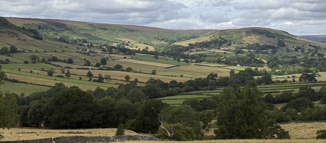
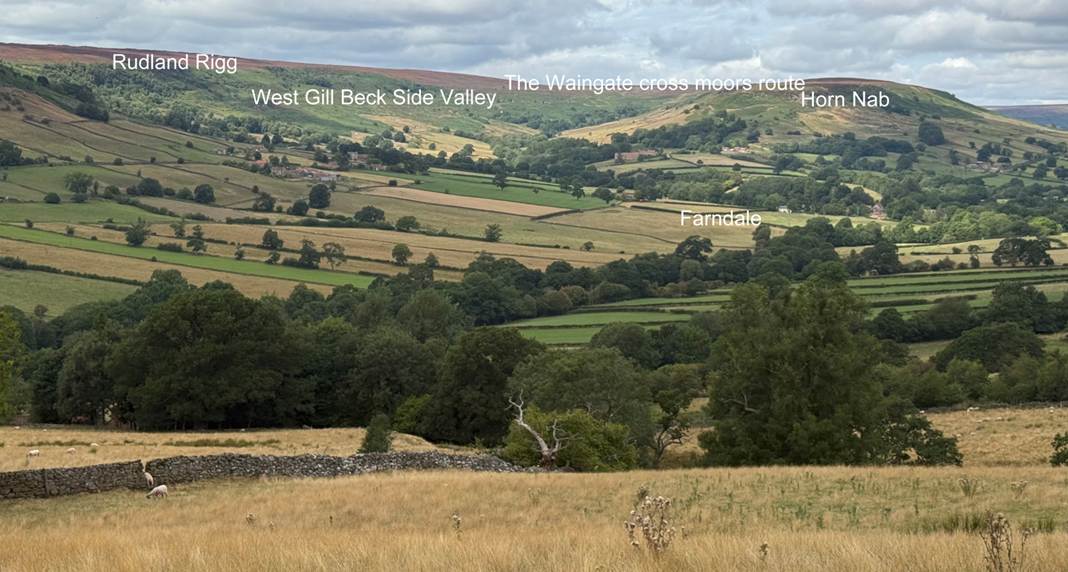
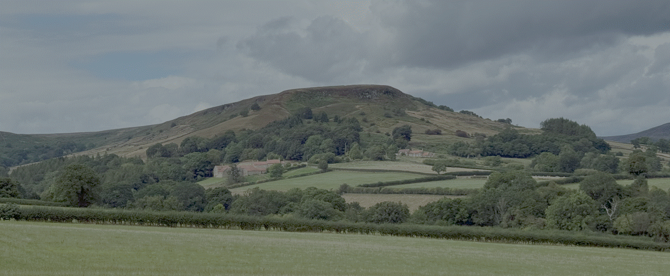
Horn Nab (to the right) jutting into Farndale with the
West Gill valley in the centre
The Horned Valley associated with Abbot Ceolfrith of
Monkwearmouth-Jarrow before his final journey towards Rome and its possible
link with Kirkdale
|
Return to the Home
Page of the Farndale Family Website |
The story of one family’s
journey through two thousand years of British History |
The 83 family lines
into which the family is divided. Meet the whole family and how the wider
family is related |
Members of the
historical family ordered by date of birth |
Links to other pages with
historical research and related material |
The story of the
Bakers of Highfields, the Chapmans, and other related families |
Headlines are in brown.
Dates are in red.
Hyperlinks to
other pages are in dark
blue.
References and
citations are in turquoise.
Context and local
history are in purple.
Geographical
context is in green.
Ceolfrith (pronounced
see-al-frith)
Ceolfrith was born in about 642 CE to a noble family. His
father, like Benedict Biscop who founded Monkweathmouth-Jarrow,
served as a comitatus (part of the royal retinue) of King Oswiu. He was
encouraged into monasticism by his brother Cynefrid, so in about 660 CE
Ceolfrith joined the monastery of Ingetlingum.
When he was almost eighteen, he
elected to put aside his secular garb and become a monk; so he entered the
monastery that is situated in the place called Ingetlingum (Life of Ceolfrith, Anonymous, Chapter 2).
According to the Anonymous Life, Ceolfrid began his religious life at a monastery called
Ingetlingum, which has been interpreted as
Gilling (Journeys from Jarrow, Richard Morris, 2004 Jarrow
Lecture, page 19).
The beginnings of an ecclesiastical
aristocracy are apparent in Deira in association with Oswine’s memorial
at Gilling. Its founding abbot, Trumhere, was a
kinsman of Ealflæd and Oswine; he was afterwards appointed bishop
in Lindsay. Ceolfrith joined Gilling at the beginning of his career.
His brother Cynefrid and their kinsmen Tunberht had
previously been abbots of Gilling. Cynefrid left to travel to Ireland.
Following an outbreak of plague in 661, Ceolfrid and Tunberht
transferred to Ripon, with Wilfred by then its abbot. Tunberht
became bishop of Hexham in 681. Whether Wilfred was related to Ceolfrith
and Tunberht
is not known - it seems likely - but he was from an elite family, with a father
of sufficient standing to have entertained the king's retinue, and his
association with sub king Alhfrith suggests Deiran origins. (Northumbria
AD 367-867, Max Adams and Colm O’Brien,
2025, page 134).
Gilling had been founded about a decade before on the
urging of Eanflæd, the wife of King
Oswiu of Northumbria, as an atonement after the Bernician King Oswiu was responsible
for the murder of his rival and kinsman, the Deiran king Oswine. Gilling was
the monastery also known as Ingetlingum founded by Oswiu after the
Battle of Wilfaresdun or Wilfar’s
Hill in 651 CE, about ten miles north-west of the village of Catterick (vico Cataractone) (Ecclesiastical History, Bede, Book 3, Chapter 14).
Bede’s Historia Ecclesiastica
relates that a conflict between King Oswiu of the Bernicians (r 642 to 670) and
King Oswine of the Deirans (r 644 to 651) resulted in the foundation of a
religious community at a place called Ingetlingum. To atone for this crime, Oswiu founded a religious community
at Ingetlingum under the control of an abbot called Trumhere.
Cynefrith, brother of Ceolfrid of Jarrow, and their
kinsman Tunberht were later abbots of the community.
(Locating Ingetlingum and Suthgedling: Gilling West and Gilling East, Thomas Pickles, Northern History, Volume 46, Issue
2, 2009, page 313). In fact Ceolfrith was not an abbot of Ingetlingum,
but a novice monk and later priest.
Trumhere was abbot of Ingetlingum from 651 CE, but
had left to become Bishop of the Mercians by 658 CE. Ceolfrith’s
brother Cynefrith may have been Trumhere’s successor.
There are two Gillings in the North Riding known
respectively as Gilling West (near Richmond and closer to the scene of the battle)
and Gilling East, closer to York (Eoforwic),
and only ten kilometres southwest of Kirkdale. There
is debate as to which Gilling was the location of Oswiu’s monastery. This is
explored further below.
In 664 CE, Oswiu presided over the Synod of Whitby and
after listening to the debate he decreed that Roman practices of Christianity
should be adopted and his kingdom became linked to Rome
and its artistic and cultural influences.
Also in about 664 CE, Ceolfrith left Gilling in search
of a stricter monastery, and became associated with Wilfred, who had argued for
the Roman association at Whitby, and in due course Ceolfrith was ordained as a
priest at Ripon. Tumberht, Ceolfrid and ‘not a few
brothers’ (non paucis e fratibus
eius monasterii) left to join the community at Ripon
(Pickles, ibid, page 316). This raises the possibility that Ingetlingum was abandoned
by a large group of its monks at this time. This was also about the time when
his brother, Cynefrith, died of plague, perhaps in the plague of 664 CE.
In 672 CE, Benedict Biscop was given land at Wearmouth
by the new Northumbrian King, Oswiu’s son, Ecgfrith. Biscop founded the
monastery of St Peter’s there. Sometime after this, he asked Ceolfrith to join
him, as his assistant.
In 679 CE Bede joined the monastery of St Peter’s as puer
oblatus.
In 681 CE, Benedict Biscop was given land at Jarrow.
Ceolfrith may have been involved in the construction of the second monastery of
St Paul’s at Jarrow, but in any event he became its
head.
Benedict Biscop and Ceolfrith were close, and they
travelled together to Rome on Benedict Biscop’s last journey there.
In 686 CE, plague ravaged the double monastery of
Monkwearmouth-Jarrow. Ceolfrith and Bede seem to have been the only monks who did
not succumb to the plague, and they tended the other dying and sick monks.
Ceolfrith had witnessed his brother’s death from plague in about 664 CE. Bede
and Ceolfrith worked closely together. Ceolfrith was Bede’s master but also
became a friend.
Benedict Biscop died in 689 CE and Ceolfrith became
abbot of both the monasteries of Monkwearmouth-Jarrow, having been the founding
head of the Jarrow community. During his abbacy, he doubled the number of books
in the libraries of the double monastery.
In 700 CE Ceolfrith instructed the monks to make three
copies of the biblical text, gathered from travels across Europe, into one
great volume or pandectum, with two copies for
Wearmouth and Jarrow, and a third, which became known as the Codex Amiatus, for delivery to Rome.
When Ceolfrith approached his final days, he resigned
as abbot. He then set off to Rome to fulfil his ambition to deliver the Codex
Amiatus Bible to Pope Gregory II. After crossing
the river Wear at Jarrow, he left Jarrow by horse, while
the monks elected Hwartberht as
their new abbot.
The Life of Ceolfrith by an Anonymous Monk of Jarrow of the Eighth
Century, chapter XXIX, tells of the appointment of Hwartberht as abbot of Monkwearmouth Jarrow in succession
to Ceolfrith, who wrote a letter of support to Ceolfrith, which he sent with
gifts to Ceolfrith who was found at Aelfberht’s
monastery, which was situated at the place called Cornu Vallis.
When this was done, a large number of
brothers came from the monastery of St Paul on Whit Sunday and they unanimously
elected Hwaeberht to be appointed to the position of
abbot. He had lived in the monastery from his earliest years and was steeped in
knowledge of the Church and the monastery and already held a responsible
position as priest. This man, the abbot-elect, immediately wrote a letter in which
he commended his father and predecessor to the apostolic pope. Hwaeberht also prepared gifts to send, and following in Ceolfrith’s footsteps with some of the brothers he read him
the letter and handed over the gifts her had brought, when he found him at the
monastery of Aelberht, situated in a place called
Cornu Vallis. (From
the translation of the anonymous Life of Ceolfrith, Two Lives of Ceolfrith, Abbot of Monkwearmouth-Jarrow,
Carolinne White, 2024, The Cambridge Anthology of British Medieval Latin,
2024, pages 174 to 190).
So en route to
Rome, Ceolfrith had first travelled to the monastery of Aelfberht
at a place called Cornu Vallis. Whitsunday in 716 CE was on 23 May 716, so
Ceolfrith left Jarrow shortly before that. It was likely that he decided to
visit his homeland before his onward journey to Rome, which he knew would be
his last.
Chapter
XXXI of the Life of Ceolfrith went on to record that at a
later date, Ceolfrith set off from his monastery on the Thursday
before the Nones of June (4 June 716 CE), intending to go down to the sea by way
of the river Humber. On the fourth day before the Nones of July, on the sabbath
(4 July 716 CE), he went aboard ship, which made three landings before it
touched the shores of Gaul. Each time he was received with honour by everydoy and treated with respect because he decided to
complete the grace of long standing perfection with
the incomparable example of virtue. (From the translation of the anonymous Life of
Ceolfrith, Two Lives of Ceolfrith, Abbot of Monkwearmouth-Jarrow,
Carolinne White, 2024, The Cambridge Anthology of British Medieval Latin,
2024, pages 174 to 190)
So he left the monastery at Cornu Vallis on 4 June 716, and a
month later, on 4 July 716, he boarded a ship on the Humber
river, with a retinue of nearly eighty men.
He arrived in Gaul on 12 August 716. The dying monk
then travelled as far as Langres in Burgundy, but he
died there on 29 September 716. The Codex Amiatinus
was rediscovered in the ninth century in Abbazia di San Salvatore, Monte Amiata in Tuscany. It was later kept in the Laurentian
Library in Florence.
Bede was deeply affected by the death of his friend
and master Ceolfrith in 716 CE (Introduction to the Ecclesiastical History, 1969, page
xxi).
The age of long journeys,
650 to 800 CE
Jarrow on the mouth of the Tyne was probably a place
of royal importance. King Oswine was perhaps buried at nearly Arbeia, a large Roman Fort in what is now South
Shields. Indeed the extent of finds in that area
suggest this may have been a Northumbrian Valley of the Kings. Jarrow
was a harbour which may have been King Ecgfirth’s
harbour called portus Ecgfridi.
Jarrow was a communications hub beside a Roman road and an excellent harbour. Bede’s
Jarrow did not exist in isolation, but formed part of a constellation of royal,
monastic and commemorative places on the lower Tyne, at a point where two axes of
communication met. As such it was a threshold to far away places. (Morris, 7 to 10). Benedict Biscop and Wilfred gained their royal reputation from
their extensive travels to Rome and the Continent. It was at Wearmouth and then
Jarrow where the royal grants of land were made.
For Northumbrian aristocracy, the
century and a half from c 650 to 800 was an age of journeys. When they came of
age, Wilfred and Biscop travelled abroad. They were followed in 690 by Willibrod,
and in the eighth century by other missionaries. A century later Alcuin made
visits to and eventually departed for the continent. The papal Legatine Mission
visited Northumbria and Mercia in 786. (Morris, page 11). Travel was an apprenticeship
for life and the prelude to a monastery’s foundation. Those who underwent
monastic preparation abroad had the opportunity to observe leaders in different
parts of Europe, and so found themselves in demand as
royal advisers at home (Morris, page 12).
Horses must have been important.
Wearmouth-Jarrow was an aristocratic house, and not
only is it likely that horses were kept and bred for local travel, but the
horses of visitors and couriers would require feeding and stabling, in turn
requiring buildings, paddocks for grazing, and accommodation for ostlers. …
Next to the horse, the other key to Anglo-Saxon travel was the ship. (Morris, page 16).
The location of Cornu
Vallis, the horned valley – Option 1, The Humber
Cornu
Vallis, where
Ceolfrith rested at Aelfberht’s monastery, has
generally been associated with Hornsea on the East Coast of Yorkshire, Spurn
Head and with Bass Rock on the Firth of Forth. The exact location of Cornu
Vallis remains debated. The notes
to the 1967 translation of the Life of Ceolfrith suggest that Ceolfrith
had ridden south in 716 CE towards the mouth of the Humber where they were
waiting for a ship to the continent. Levisham
suggests that Aelfberht’s monastery may refer to the
monastery of Willinbroad’s father, Wilgils and also notes that this may have been where
Ceolfrith waited for a ship to take him down the Humber estuary (England and the Continent in the Eighth Century, page
55 note 1, The World of Bede, Peter Hunter Blair, 1971, page
192). The Anonymous History of Abbot Ceolfrith, written around AD
700, recalls Ceolfrith’s voyage to Gaul. Ceolfrith took a boat from the
monastery at Cornu Vallis, which can be identified as either Hornsea on the
East Yorkshire coast, or possibly Spurn Head (Coastal Landscapes and early Christianity in Anglo Saxon
Northumbria, David Petts, Estonian
Journal of Archaeology, 2009, Volume 13, pages
79 to 95).
However this is not quite right.
Ceolfrith didn’t take a boat from the monastery, but after leaving the
monastery travelled for a month before he embarked from the Humber.
Wilgils of Ripon, also known as Wilgisl
and Hilgis, was a seventh century saint and hermit, who was the father
of St Willibrord. As stories of his hermitage on the banks of the Humber estuary
spread, Wilgils was granted royal patronage and
founded an oratory and church at the mouth of the Humber. He is known mainly
from the
Life of St Willibrord by Alcuin,
but is also mentioned by Bede. Alcuin wrote that Wilgils
was paterfamilias of Alcuin's own family and that Alcuin had inherited Wilgils' oratory and church, suggesting a close familial
relationship. Wilgils’ monastery was on the Humber,
but this is why cornus vallis
has been associated with him on the (possibly erroneous) assumption that the cornu
vallis monastery was on the Humber.
It is not correct
to say that Ceolfrith boarded his ship from the monastery. The text tells us
that he set forth from the monastery and boarded his ship a month later on the
Humber. This suggests that the monastery of Cornu Vallis was not on the Humber
as is often suggested. (Religion,
Society and Politics and the Liber Vitae of Durham, Elizabeth Briggs, 1987, page 202). It has been
suggested that Ceolfrith waited at the monastery for an opportunity to sail,
but this seems a less plausible explanation. It seems more likely that
Ceolfrith had travelled to his homeland for a final time before he set off for
the Humber, and then Rome.
Cornu
Vallis was
therefore probably at a location some distance from the Humber, some midway
point between Jarrow and the Humber.
Aelfberht’s monastery
The Life of
Ceolfrith refers to the cornu vallis
monastery as Aelfberht’s monastery. I have found no other reference to Aelfberht,
who was presumably its abbot.
Aethelbert
who was later appointed Archbishop of York in 766 CE and died on 8 November 780
CE, was a kinsman of York’s archbishop Ecgbert and brother of King Eadberht of Northumbria
(reigned 738 to 758 CE). He was a scholar and teacher, who taught scholars
including Alcuin at the cathedral school in York. He was placed in a monastery
as a young child before he was a pupil at York. Aethelberht was sometimes
referred to as Aelbert (The Cambridge Anthology of British Medieval Latin,
2024, index).
Aelfberht was either an unknown abbot or the future
archbishop of York. There is no suggestion that the monastery at Cornu
Vallis was Wilgils’ monastery.
The location of Cornu Vallis,
the horned valley – Option 2, Kirkdale
Kirkdale in Ryedale, close to the town of
Kirkbymoorside, may have an early pagan history at a place where the Hodge Beck
disappears in periods of dry weather to reappear further downstream. It is also
possible that Kirkdale was a place of burial
associated with the villa at Beadlam (St Gregory’s Minster, Kirkdale, North Yorkshire, Archaeological
Investigations and Historical Context,
Philip Rahtz and Lorna Watts, 2021, 288).
Nearby Lastingham
had been founded of Celtic/Lindisfarne tradition in 653 CE, but Kirkdale was
founded after the Synod of Whitby had tied Deiran loyalty to Rome and its pope
Gregory the Great. Thus when a church was founded at
Kirkdale in about 685 CE, it was dedicated to St Gregory. Kirkdale and its
vicinity seem to have been staunchly Roman in the Celtic-Roman debate of the mid
seventh century. That is perhaps not surprising given its rich Romano-British
inheritance.
Indeed Kirkdale may have already been an important Christian site prior
to 685 CE. When King Edwin of Deira fell at the Battle of Hatfield Chase near
Doncaster in 633 CE, his body was taken temporarily to York in a porticus
or chapel dedicated to St Gregory in York and his body was then moved to a porticus
again dedicated to Gregory, at Whitby. It has been speculated that, since the journey
from York to Whitby would have taken more than a day, and Kirkdale is about
midway, Edwin’s body may have lain temporarily at Kirkdale. (St Gregory’s Minster, Kirkdale, North Yorkshire,
Archaeological Investigations and Historical Context, Philip Rahtz and Lorna Watts, 2021, 292 to 293).
Kirkdale, a
minster by 685 CE, may already have been a place of ancient religious
importance before that time.
minster was the English
equivalent of monasterium, which was not an association
with later monasticism, but to more varied types of religious establishment. So minster does not particularise the religious
purpose of the original building. It doesn’t mean that it was a monastery, nor
a minster in the modern sense. It may have been referred to as a monastery,
though its function may have been more nuanced.
Some scholars
believe that Cornu Vallis could have been at Kirkdale.
One
point however remains: the likely identification of Kirkdale with Aelberht’s monastery which is located at the place called .. Cornu Vallis. The case for equating Kirkdale with Horn
Vale is cumulatively powerful. If we are right in associating Gilling East with
the monastery of Ceolfrid’s youth, then Horn Vale
would logically lie somewhere on the route to Holderness and the Humber. For
reasons already given, at some point before the eleventh century, Kirkdale,
Gilling and Hovingham were closely linked. For archaeological and sculptural reasons,
Kirkdale is also implicated: in particular the
extraordinary tomb covers, though later in date than Ceolfrid, suggest not only
that Kirkdale was a place where holy men or women were buried, but also that
Kirkdale and Wearmouth-Jarrow enjoyed some close and otherwise unattested
connection.
The
second element of the place name Kirkdale is in the Scandinavian translation of
vallis. Curiously, and perhaps coincidentally, the
valley in which the church stands does curve like a horn.
This is best seen from the air, but the likeness would have been apparent to
travellers approaching from the north, as they descended from the moor. This
view would have been familiar to travellers, since Kirkdale stood beside
Rudland Rigg, a medieval trunk road that descended from the upland heath after
crossing the moors from the north. This was one of the two main routes
available to Ceolfrid and his party, and three miles
up from it is Horn Ridge.
So much
is speculative, but the association between Kirkdale and Cornu Vallis is surely
settled by the fact that four centuries later the family named Cornuwala and variants like Cornuallia
still existed as a personal name in the area where Kirkdale is located. In the
mid twelfth century Samson de Cornuallia witnessed
gifts to Rievaulx in Thornton and Staincroft and as Cornuwala in Skiplam, an area adjoining Kirkdale, Farndale
and Bransdale. Samson was Roger de Mowbray’s man. Around 1160 Roger gave all of Hoveton to Rievaulx,
together with four bovates formerly held by Samson. The Dean and Chapter of
York subsequently attested the lands release to Rievaulx. (Rievaulx Cartulary,
edited by J Atkinson, Surtees Society, Volume 83, 1889, pages 30
to 31, 40,
170
and 214
to 215).


Whether
or not Gilling East was the monastery that Ceolfrid
entered in his youth, the evidence points to Kirkdale as the Horn Vale where he
paused in old age, on his last journey from Jarrow.
(Journeys from Jarrow,
Richard Morris, 2004 Jarrow Lecture, page 23, see also St Gregory’s Minster, Kirkdale, North Yorkshire,
Archaeological Investigations and Historical Context, Philip Rahtz and Lorna Watts, 2021, page 293).
The name Cornu
Vallis seems to be a reference a horn-shaped valley, aligning with the
topography of Kirkdale. Cornu vallis in Latin
generally translates as corner of the valley (the Latin word for horn is
buccina). Latin was the usual language of the church. However
the celtic name cornu nab referred to the horn shape of a ridge. Cornu vallis referred to a horn shaped valley. Cornus
in its horn meaning was thus associated with earlier Celtic/Iron Age cultures
and to established places of ancient importance (The name of Bernicia,
D Breeze, Antiquities Journal, Volume 89, 2009, pages 73 to 79). It has been suggested that the cornu or
horn might have been associated with the horn of cattle, but it seems more
likely to have derived from a feature of the landscape. Richard Morris
suggested a Scandinavian origin of vallis. Whether
Scandinavian or Celtic, it suggests a feature of the landscape of considerable
antiquity.
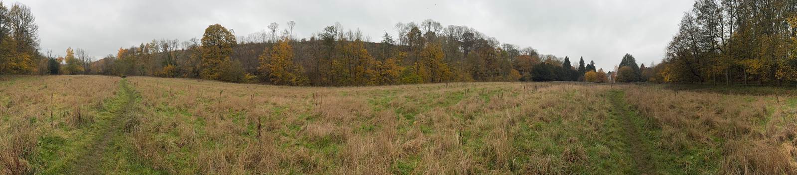
The
horn shaped valley along the Hodge Beck in which St Gregory’s Minster lies
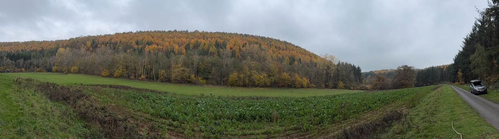
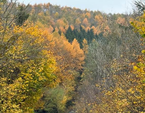
The
continuation of the curved valley north of Kirkdale
Ceolfrith’s cornu vallis was likely to have
been a place of ancient religious significance, so an Iron Age derivation is
not surprising, and a place of religious significance back to the Iron Age and
beyond was not unlikely.
Indeed Augustine’s
mission was instructed by Gregory to be ready to deal with pagan shrines, where
animals might have been slaughtered, by taking such places over for Christian
use (Ecclesiastical History, Bede, Book
1, Chapter 30). The Kirkdale archaeologists have suggested that Cornu
Vallis might have been associated with a well known meeting place, that could be identified by
name. (St Gregory’s Minster,
Kirkdale, North Yorkshire, Archaeological Investigations and Historical Context, Philip Rahtz and Lorna Watts, 2021, page 293).
Richard
Morris favoured the horn shaped valley of Kirkdale itself as the possible Cornus
Vallis, but he also noticed the Horn Ridge not so far to its north.
The
Horn Nab or Horn Ridge juts into Farndale, about 9 kilometres north of
Kirkdale. It is an ancient
place with tumuli and other features dating to at least the Bronze Age. Its
name derives from Celtic cornu.
Below
the crag are the farms of Knaysbeck and Keysbeck which were settlements in the
Anglo-Saxon-Scandinavian period and were likely to have been occupied prior to
that. They lie in the valley of the West Gill Beck, overhung by the Horn Nab.
Most of Farndale was wilderness forest but this corner of the valley seems to have
been occupied from a much earlier time, accessed from the Rudland Rigg, and the waingate
route. Whilst Farndale was a forested wilderness, the higher ground of the
West Gill valley which lies just below Rudland Rigg and the Horn Nab, seem to
have been occupied from much earlier times, presumably accessed from the cross
moors route of Waingate, which passed adjacent
to the valley and Horn Nab.
A number of ancient routes across the moors
headed towards Cleveland from Kirkdale and its vicinity. Thurkilisti
passed immediately adjacent to Kirkdale, whilst the Waingate
route joined nearby Kirkbymoorside across Rudland Rigg overlooking Farndale,
and on to Baysdale Abbey and Guisborough. It became a
pilgrim’s route in time, and may have been used as
such for many centuries before the founding of Baysdale
Abbey and Gisborough Priory.
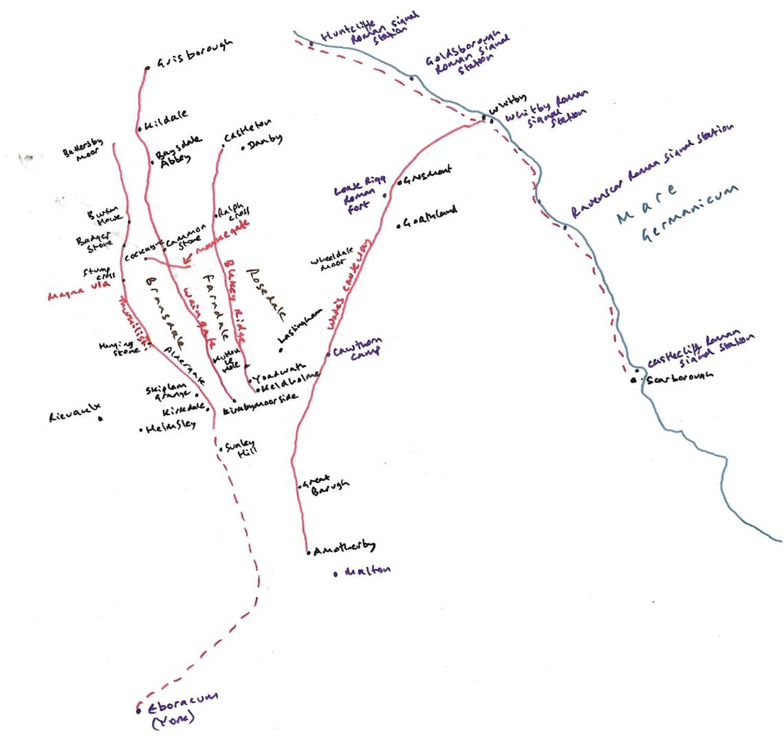
A
traveller from Monkwearmouth-Jarrow was likely to have followed the Waingate route if travelling across the moors to the
lands around Kirkdale, Gilling East and Ceolfrith’s
possible homeland. Shortly before arriving at Kirkdale on horseback, such a
traveller would have passed Horn Nab, the horned ridge jutting over the valley
below it, which may have been a place of some importance after crossing the
wilderness of the moors. From there, on horseback, Ceolfrith and his retinue
may have descended to Kirkdale and arrived there within about an hour. A horse typically
trots at speeds between 8 to 12 miles per hour.
About
9 kilometres apart, Kirkdale and the Horn Valley, may have had a close
association, accessed along Waingate.
Ceolfrith had
been a monk at Gilling and Ripon. If the monastery of his youth had been
Gilling East, then the lands around Kirkdale was his homeland. A place of
ancient religious importance may have been an obvious location for Ceolfrith to
head to prior to his final journey to Rome. Indeed Kirkdale
seems to have been a place strongly Roman Christian culture in the Celtic-Roman
debate and Ceolfrith, Benedict Biscop, Wilfred, and later Bede were all most
certainly in the Roman camp in the Roman-Celtic debate. So
this may have been a return to his homeland. Indeed it
is suggested that this was a journey intended to reconnect him with the places
of his youth (Lastingham
and its sacred landscapes, I Wood, 2008
Lastingham Lecture). Gilling East is only ten kilometres to the
southwest of Kirkdale.
The location of
Kirkdale is also consistent with the length of time Ceolfrith took before he
boarded ship on the Humber.
The location of Ceolfrith’s Gilling
Whilst the traditional view is that the monastery
founded by Oswiu where Ceolfrith stayed for a while before his journey towards
Rome was at Gilling West, north of Richmond, Richard Morris and Ian Wood
advocate that it was located more likely to have been at Gilling East. Thomas Pickles
is more sceptical and advocates that the traditional view linking Ingetlingum
with Gilling West is more likely. If indeed the location of the monastery
founded by Oswiu in 651 CE and attended by Ceolfrith between about 660 to 664
CE was at Gilling East, close to Kirkdale in the Vale of Pickering, this would
tend to reinforce the association of Kirkdale and Cornu Vallis.
Gilling East sees
a break in the higher ground between the Howardian and Tabular hills, forming a
natural routeway out of the Vale of Pickering and onwards to the Vale of York
and the main Roman roads. This site, at the edge of the Deiran coreland, seems the more probable location for an assertive
and politically charged statement of Deiran kingship than Gilling West. Its
church as a sculptural fragment built into the south chancel wall of the
present church. Scroll moulding, minimal foliage and the rigidity of its
medallions associate this stylistically with the 8th century Acca’s Cross in
Hexham. (Northumbria
AD 367-867, Max Adams and Colm O’Brien,
2025, page 142; Corpus of Anglo-Saxon stone sculpture III: York and Eastern
Yorkshire, J Lang, 1991, British Academy, Gilling
East).
The case for Gilling East (Journeys from Jarrow, R Morris, 2004 Jarrow Lecture, Monasteries and the geography
and power of Bede, Ian N Wood, Northern History,
Volume 45, Issue 1, page 17 and 18).
When Ceolfrid left Jarrow on
his final journey, he had arranged for a ship to meet him at the mouth of
the Humber. On the way he stops at a monastery headed by a certain Aelberht at an unidentified place called cornu vallis, ‘horn vale’. After Hwaetberht
had caught up with him the journey continues. On 4 July he boards a ship at
the mouth of the Humber, and this may have been from the monastery at Spurn
Head (Morris page 19 to 20).
Whilst it is tempting to think that he may have
decided to leave from the Humber rather than from Jarrow in
order to keep his plans secret and avoid being persuaded by his fellow
monks to stay, by the time he left, his plans were already known. It is also
notable that the departure point on the Humber is 140 miles away from Jarrow. A
possible explanation for Ceolfrid to have left from
the Humber rather than simply set off directly from Jarrow is that he had farewells
to make, and perhaps more consents to seek, along his way (Morris, page 20).
Since both the first and second monks of
Ingetlingum were Ceolfrid’s kinsmen, it seems
likely that it was at Ingetlingum that Ceolfrid
had passed his childhood. Therefore we must first
ask where Ingetlingum was. The name probably equates with the place
names Ghellinge or Gilling that appear in eleventh
century sources and today as Gilling. It has been thought that Ingetlingum
was Gilling West, which is close to the battle site and was supposed to have
been Oswine’s hiding place after the battle where he was betrayed and murdered.
However it seems more likely that Oswine would have
put more distance between him. Oswine was also betrayed by someone he believed
to be a loyal friend, which suggests a site deeper into Deiran heartland,
which is where the other Gilling is to be found. (Morris, page 21). Ceolfrith’s
route was likely to have taken him in that direction. Gilling East is only one
among a number of Anglian monasteries that stood in or
close to the Coxwold-Gilling gap.
Ian Wood and Richard Morris argue that as well as groups
of monasteries that follow the coast from the double monastery at Coldingham to Spurn in the south, including Whitby,
Hartlepool, Wearmouth, Jarrow, Tynemouth, a hermitage on Coquet and
Lindisfarne, and another group on the Lower Tyne stretching to Hexham, the
group in the Vale of Pickering of which Lastingham is the most famous perhaps
also linked with the coastal group of monasteries (Wood page 15).
Amongst the Vale of Pickering group, Philip Rahtz and
Lorna Watts has shown clearly that Kirkdale was the site of an early monastery
and Richard Morris has convincingly argued that it was in fact a house known
from the Anonymous Life of Ceolfrid as Cornu Vallis.
Ceolfrid visited this last monastery en route for Rome in 716, having given up the abbacy of
Wearmouth-Jarrow. He probably knew the Vale of Pickering well. Before joining
Benedict Biscop at Wearmouth, he had been a monk, first at Gilling and then at
Ripon. Wood explains that after the battle, Oswine had fled to a place of
hiding at Ingetlingum, after dismissing his followers. Wood doubts
whether this would in fact have been so close to the battle site. He also
points out that Gilling West does not have evidence of monastic sculpture
earlier than the ninth century. Gilling East has sculpture that could be
earlier and the association of Kirkdale and Gilling and the cornu vallis of Ceolfrith’s
monastery makes more sense. These factors and the overall importance of the
Vale of Pickering may suggest that this region was the central zone for the
Deirans and therefore that it is the more likely site of Oswin’s murder and
Oswiu’s monastery. Wood also pointed out other monasteries at the edge of
the Vale – Crayke, Coxwold, Stonegrave,
Kirkby Misperton and above all Hovingham. We thus have a group of five
unquestionable monastic houses and three possible ones within a very tight area.
Further even granted the fact that all or most land with which monasteries were
endowed came from the king, the royal connections of this group are striking –
they would have had a particularly significant role in offering prayers for
kings and their families, and thus of preserving and celebrating their memory.
Aethelwald was certainly associated with Lastingham and possibly also with
Kirkdale, Gilling was founded by Oswiu in memory of Oswine, and Crayke was a foundation of Ecgfrith. (Wood Page 16 to 18, Morris page 22). Kirkdale may also have been the resting place of the body of
King Edwin in 633 CE on its procession from York to Whitby.
A little to the north and east in
the limestone Tabular Hills are place names like Gillamoor (‘Gilling Moor’) and Hoveton
that in the eleventh century imply some earlier affiliation between Gilling and
Hovingham, presumably as appurtances that had
provided particular kinds of resource. (Morris, page 22).
Excavation and sculpture now suggest
that religious use of the site can be traced back at least to the eight century. Excavation has yielded finds reminiscent of
Wearmouth-Jarrow, whilst two richly carved stone tomb covers, one carved with
the skeupmorphic likeness of textile, identify
Kirkdale as a place where magnates were buried. Further Alan Thacker has
pointed out that the draping of a richly woven cloth over a free
standing tomb was a way of proclaiming sainthood. Such tombs were free standing,
typically near the high altar, and it was normal for those in them to have
earlier been buried outside, their bringing in often being arranged to coincide
with the dedication of a new building. The carved palla
is thus likely to denote someone exceptional and the intention, if not the
actuality, of a tomb cult. (Morris,
page 22). Lastingham was
close by. The presence of so many houses in close proximity
raises many questions. Richard Morris feels all this points to the likely
association of Kirkdale with Cornu vallis.
Gilling East is only two kilometres south of Oswaldkirk, named after Oswiu’s brother, the Northumbrian
King Oswald who had been slain by the pagan, Penda in 642 CE.
The fact that Gilling West is closer to Ripon, to
where Ceolfrith and brethren moved, also supports the Gilling East theory (Lastingham in its sacred landscapes, Ian Wood, Professor of Early Medieval History, The Fifth Lastingham
Lecture, 2008, page 14).
The case for Gilling West (Locating Ingetlingum and Suthgedling:
Gilling West and Gilling East, Thomas Pickles, Northern
History, Volume 46, Issue 2, 2009, pages 313 to 325).
Gedling is the linguistic root of
the place name Ingetlingum. Gedling is also probably the root of the place name
Gilling West (North Yorkshire) and the present village
lies some seven miles north west of Catterick. It has
generally been assumed, therefore, that Ingetlingum was at Gilling West. However the case for Gilling West has been assumed rather
than established. (Pickles
page 313).
Richard Morris and Ian Wood have
acknowledged the potential case for locating Ingetlingum at Gilling West, but have constructed a plausible case for Gilling East
as an alternative. (Pickles
page 314).
In a separate episode of contemporary monastic
history, Cuthbert was given land in Cumberland and a vill
called Suthgedling by King Ecgfrith (Anonymous Historia de Sancto Cuthberto). This place has the same root with Gilling as well. This raises
a possible connection between Oswiu’s Ingetlingum and Cuthbert’s Suthgedling. Close consideration of the HSC
passage on Suthgedling within the context of
the rest of the work suggests that when the author wrote of Suthgedling
he was thinking of Gilling East. (Pickles, page 315).
However Thomas Pickles, whilst acknowledging the alterative argument for Ingetlingum
being Gilling East, prefers the location of Gilling West. Of course, it
remains just possible that Ingetlingum was Gilling East, but the case for this
is weak by comparison, Pickles page 320). The argument for Gilling West is carefully argued by Thomas
Pickles, and there follows a summary of his main arguments. These are
necessarily abbreviated and the full argument is better absorbed by reading his
full article.
· Bede records that the battle site of Wilfaresdun
is 10 miles northwest of Catterick, but he doesn’t give a location for Ingetlingum, but only says that Oswine diverted (diverto) there. The fact that he didn’t give a
location suggested that the diversion was a short one, to the vicinity of the
battle site. Gilling West is 7 miles northwest of Catterick (Pickles, page 318).
· The evidence of Domesday Book suggests that Gilling West was a
royal site. Whilst Gilling East lay in the heartland of the Kingdom of the
Deirans and this area was a particular focus for the foundation of religious
communities, by the time of Domesday Book Gilling East comprised two
holdings of limited size and it was Hovingham and Kirkbymoorside by then that dominated
the vicinity, not Gilling East. In contrast Gilling West was held before the
Conquest by Earl Edwin. Gilling West was apparently a royal centre controlling
a wider territory of obligation, which was on loan to an earl in the eleventh
century; its mother parish is likely to be a relic of the relationship between
an early religious community and the territory of obligation within which it
was founded. (Pickles page 320).
· The survival of the place name Gillamoor
might hint that Gilling East once controlled a wider territory, but it is
equally possible that Gilling East simply had rights over an outlying patch of
moorland. (Pickles 319 to 321).
· Suthgedling may
have been Yetlington in Northumbria, but the best
solution is that it was Gilling East. Suth might be a prefix to distinguish
it from Gilling West. (Pickles page 322).
· Ingetlingum was more likely to have been at a
peripheral location. Richard Morris and Ian Wood have emphasised the
reciprocal relationship between power and the topography of religious
patronage; in particular they have drawn attention to
the significance of the Tyne valley and the Vale of Pickering as strategically important
sub regions that were foci for unusually dense concentrations of religious
communities. Indeed, it was in considering the density of religious patronage
in the Vale of Pickering that they proposed the relocation of Ingetlingum from
Gilling West to Gilling East. However Thomas
Pickles feels that placing Ingetlingum at Gilling West does not
undermine the importance of the Vale of Pickering. In 651 CE, Oswiu’s control
over Deira was still very limited and there is no recorded monastery in the territory
of the Deirans recorded before 651 CE (Lastingham was
founded two years after Ingetlingum in 653 CE). Granting royal land to found a monastery was a political act. Granting land to a
Deiran which lay on the border of the territory between the Bernicians and the
Deirans and which was of extremely high strategic value was a signal of trust
between two peoples: Gilling West, its soke estate and its mother parish dominate
the junction between three Roman roads, leading south into the Vale of York,
north to the Bernicians and west over the Pennines into British territories,.
Taking the opportunity presented by these events provided a way for an outsider
to introduce monasticism into a subject territory, but at the periphery rather
than at the heart of that territory: indeed, given the circumstances, it may
only have been acceptable at a peripheral location. (Pickles page 325).
Discussion
We cannot
be sure whether the location of the monastery of Ingetlingum was Gilling
West or Gilling East. Both sites have revealed archaeological evidence of early
religious activity. The case for Gilling West is primarily focused on its
proximity to Oswine’s murder after the battle of Wilfaresdun.
I am more persuaded that the monastery was founded in more central Deiran
territory, closer to York. I’m less persuaded by the political incentive to found the monastery at the periphery. Although Oswiu was reestablishing
a Bernician claim over Deira in 651 CE, there is evidence that suggests that
Kirkdale may have been a place of importance for the Deiran royalty from as
early as Edwin’s death in 633 CE, even if only a resting place for Edwin’s body
en route to Whitby. By its dedication
to St Gregory in about 680 CE, after the Deiran adoption of the Roman form of
Christianity, Kirkdale and its vicinity was clearly a place firmly rooted in
the newly accepted Roman traditions. Gillamoor may
have been associated with Gilling, and Oswaldkirk
with King Oswald. Cuthbert’s Suthgelding is
generally agreed to have been Gilling East which seems to support rather than
contradict the association of Gilling East with the monastery.
It
seems particularly persuasive that in the twelfth century, the family named Cornuwala and Cornuallia
subsisted in the vicinity of Kirkdale, suggesting that cornu vallis was indeed a name associated with the region, and
therefore a likely site for the monastery visited by Ceolfrith.
If Ingetlingum,
Ceolfrith’s first monastery, was indeed Gilling East,
this strongly supports the theory that Ceolfrith was returning to his homeland,
to say farewells before his final departure towards Rome. If his first
monastery was at Gilling West, this does not exclude the possibility that Aelberht’s monastery at Cornu Vallis was still
Kirkdale. The term monasterium, was not always an
association with monasticism, but to more varied types of religious
establishment. By 716 CE, Kirkdale was certainly at the centre of Roman
Christian culture, close to the Deiran capital.
Given
the vicinity of a cornu or horned ridge jutting into the edge of the valley which is a branch of Farndale, this may support the
theory that this was Ceolfrith’s horned valley, and
Kirkdale, the monastery loosely defined as a minster. Cornus vallis may have described the valley of Kirkdale itself,
and/or the nearby Horn Rigg, an antique place which has left reminders of its
past back to at least the Bronze Age, overlooking its own valley. Kirkdale may
have been associated with Cornu Vallis, and cornu may have been
chosen to describe several features of the local landscape.
Kirkdale
is thus a place in a likely locality, probably Ceolfrith’s
homeland, likely to have been referred to as the horned ridge close to the
Kirkdale and Lastingham monastery/minsters.
If Kirkdale is
the Cornu vallis where Ceolfrith spent his
time before travelling a month to embark from the Humber on his final voyage
towards Rome, then we can draw a number of deductions
about Kirkdale and its vicinity.
Kirkdale’s association with Cornu vallis
reinforces Kirkdale’s importance as a place of
ancient religious significance, adjacent to the Waingate
and Thirkilisti routes, in the homeland of
Ceolfrith. Though the minster was founded in about 680 CE, Kirkdale may have been
the temporary resting place of King Edwin in 633 CE, and a prior pagan site,
and perhaps associated with burials from the Beadlam estate in Roman times.
Kirkdale’s association with Ceolfrith might suggest an association between
Kirkdale and the double monastery of Monkwearmouth-Jarrow at the mouths of the
Tyne and Wear and as an important religious site in the wider context of early
Northumbrian Christianity.
There may have been some religious association between Kirkdale
and Horn Ridge adjacent to Waingate and overlooking
Farndale. By the time of the Domesday Book, Kirkdale, which we know from its
sundial had been rebuilt by Orm in about 1055, was in the possession of Torbrand, son of Karli. Torbrand may have been of the same
family as the priest of Kirkdale church, Brand. As Orm’s primary interest in
Kirkdale is evidenced by the sundial, this seems likely to have been some form
of secondary interest to Orm’s, but Torbrand was recorded
in the Domesday Book as the effective owner. Bransdale is Brand‘s
dale, and is probably associated with the same family.
We therefore have an association between Kirkdale and both Farndale and
Bransdale, suggesting they were all part of the same political entity.
The Domesday Book
evidence and the eighth century evidence of the association between the horned
valley, Ceolfrith and Kirkdale, all support the thesis that the wider estate of
Kirkbymoorside comprised
Kirkbymoorside, Kirkdale, the berewicks
nestled at the northwest corner of the Vale of Pickering, as well as the
wilderness lands of the moors and dales to the north. The estate of
Kirkbymoorside was a place of Anglo Saxon
significance.
Bibliography
Locating Ingetlingum and Suthgedling:
Gilling West and Gilling East, Thomas Pickles, Northern
History, Volume 46, Issue 2, 2009, pages 313 to 325.
Lastingham and its sacred landscapes, I
Wood, 2008 Lastingham Lecture.
Journeys from Jarrow, R Morris, 2004 Jarrow Lecture.
The name of Bernicia, D Breeze, Antiquities Journal, Volume 89, 2009, pages 73 to 79.
Two
Lives of Ceolfrith, Abbot of Monkwearmouth-Jarrow, Carolinne White, 2024, Cambridge University Press, The Cambridge
Anthology of British Medieval Latin, page 174 to 190.
Monasteries and the
geography and power of Bede, Ian N Wood, Northern History, Volume 45, Issue 1, page 17 and 18.