The vicinity of Farndale in the Mesolithic Period (9,000 BCE to
3,000 BCE)
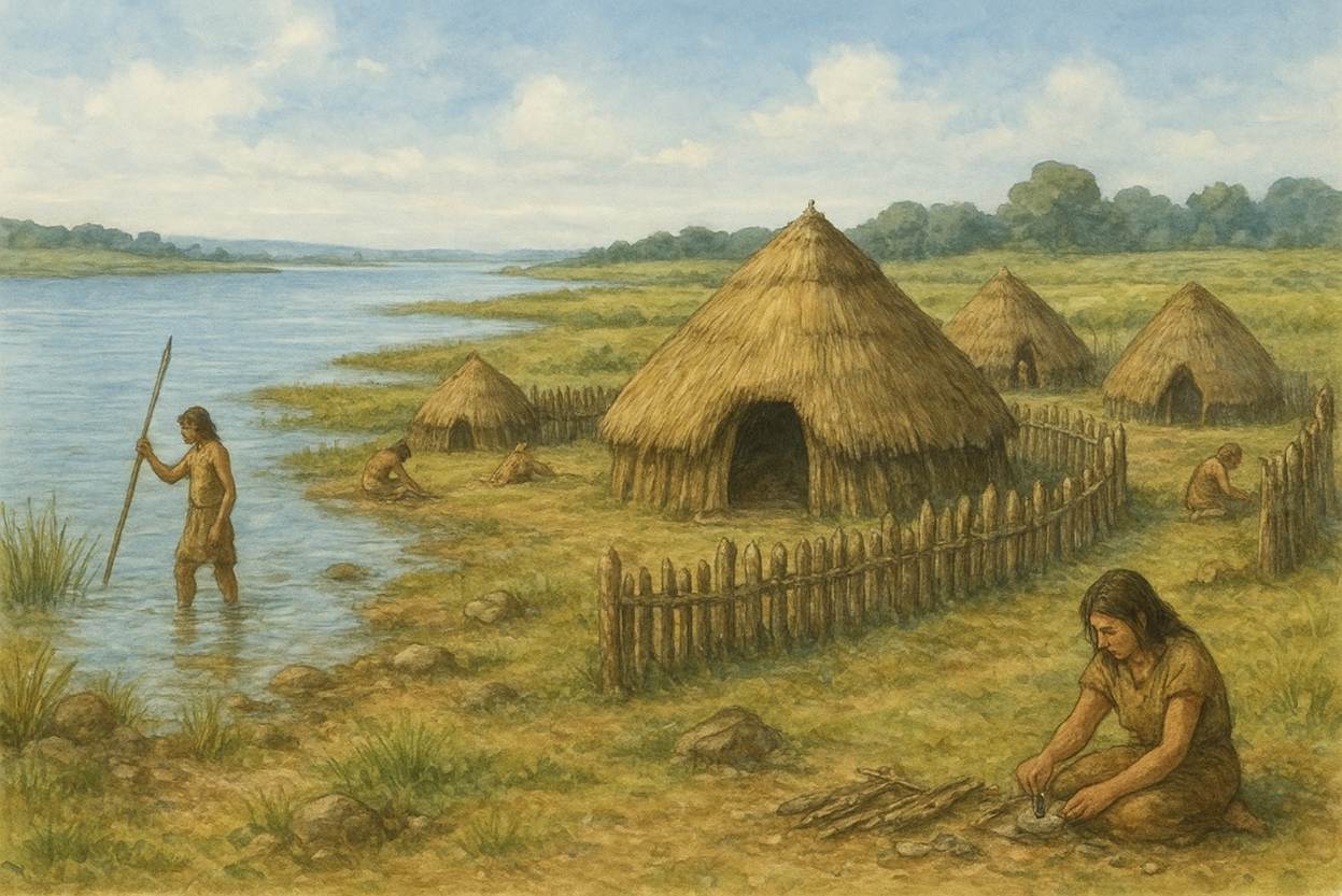
The period
of early nomadic or semi nomadic hunters who left little mark on the landscape,
but were deeply rooted in the natural world
FAR00001C
|
Return to the Home Page of the Farndale Family
Website |
The story of one family’s journey through two
thousand years of British History |
The 83 family lines into which the family is divided.
Meet the whole family and how the wider family is related |
Members of the historical family ordered by date of
birth |
Links to other pages with historical research and
related material |
The story of the Bakers of Highfields, the Chapmans,
and other related families |
Dates are in red.
Hyperlinks to other pages are in dark blue.
Headlines are in brown.
References and citations are in turquoise.
Context and local history are in purple.
BCE - Before the common or current era. The contemporary equivalent of
BC.
CE - Common or current era. The
contemporary equivalent of AD.
kya – abbreviation for a thousand years
YBP – Years before present
Go back to the
Palaeolithic Period.
Context – the Middle
Stone Age
11,000 YBP, 9,000 BCE
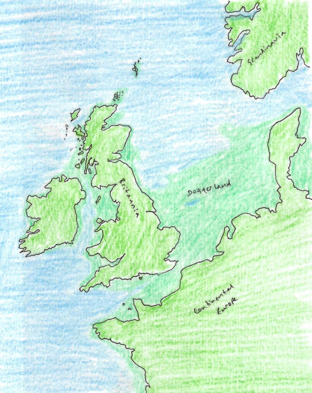
The
Middle Stone Age was the period after the ice had receded by about 11,000 years
ago. At that time, there was a land bridge with continental Europe, across the
southern half of the North Sea, known as Doggerland. Early stone age hunters
were able to wander from north Germany and Jutland to eastern England in search
of food and shelter.
There is an In
Our Time podcast, Doggerland, and the humans, plants and animals once
living on land now under the North Sea, submerged during the Mesolithic.
Map 1 - Sealevels 11,000 YBP, showing the Doggerland connection
Mesolithic Ryedale
An analysis of early settlement
patterns undertaken in the 1980s mapped out Mesolithic settlement patterns
within a 6 mile radius centred on Helmsley. A circular area six miles in
radius with the centre at Helmsley was chosen and it was decided to analyse the
change in settlement patterns between the Mesolithic (beginning 7600 B.C.) and
the Domesday Book (1086). The programme of investigation began with the mapping
of settlement sites for each of the six periods.
The earliest settlement pattern we have
in this region, that of the Mesolithic period, is probably also the most
inaccurate and misleading, for in this era before man had invented farming, he
lived a nomadic, hunter-gatherer existence and did not live in permanent
settlements, instead moving around seasonally, following the movements of the
animals he lived on. However, he does seem to have settled in some areas for an
extended period of time, and these sites can be identified by the piles of
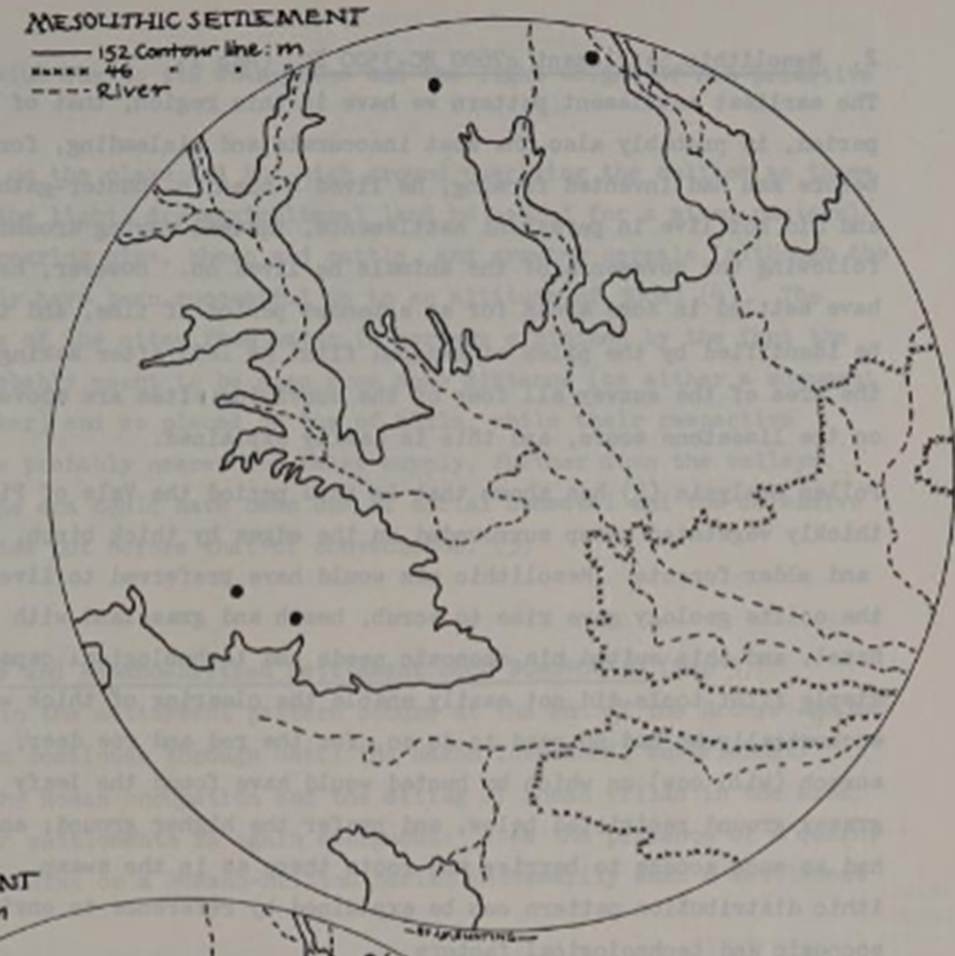
knapped flint he left after making his tools. In the area of the survey all
four of the surviving sites are above the 152m contour
on the limestone moors, and this is
easily explained.
Pollen analysis (Prehistoric Environments, R.L. Jones
et al in Spratt’s The Prehistoric and Roman Archaeology of North East
Yorkshire, 1982) has shown that in this period the Vale
of Pickering was a thickly vegetated swamp surrounded on the edges by thick
birch, elm, lime, oak and alder forests. Mesolithic man would have preferred to
live higher up where the oolite geology gave rise to scrub, heath and grassland
with some pine and hazel, and this suited his economic needs and technological
capabilities. His simple flint tools did not easily enable the clearing of
thick woodland, and economically he had no need to do so, for the red and roe
deer, wild pig, and auroch (wild cow) on which he
hunted would have found the leafy browse and grassy ground restricted below,
and prefer the higher ground; and man would have had as much access to berries
and roots there as in the swamp. Thus the Mesolithic distribution pattern can
be explained by reference to environmental, economic and technological factors.
(A look at Ryedale Settlement Patterns, Ryedale Historian, Volume 12,
1984, page 31).
The last glaciation left a series of smaller lakes and
meres and a vast deposit of silt and mud on the bed of the great Lake
Pickering. The River Derwent, which before the Ice Age flowed towards the North
Sea at Scalby Mills, had forced a way through the large overflow channel, the
Kirkham Gorge, and thence to the Humber. Water also drained into what was to
become the South Bay at Scarborough by the gap between Oliver's Mount and
Seamer Nabs. The Mere, now converted into an artificial lake, was the last remnant
of several such sheets of water. On the shores and sandbanks of these receding
meres, wildlife abounded. Narrow reed swamps fringed the shore and aquatic
plants, many of which formed part of the food of the Mesolithic folk, grew in
profusion. The higher land was densely forested; birch was the dominant tree,
willow was abundant and later, as the warmth increased, hazel became
predominant. (A History of Helmsley Rievaulx and District, editor, J McDonnell, 1963).
As the climate warmed, the mosses and lichens on which
the cold weather animals fed began to be replaced by grass and trees, birch,
alder and willow. While the ways from Europe were still open, the spread of
grassland enticed herds of different animals into Britain: deer, horses, wild
cattle, wild pigs. (The Little History of Yorkshire, Ingrid Barton, 2024, page 12).
By about 8000 BC, the population had expanded
sufficiently that open sites in a variety of locations were being established.
Other changes had taken place as the climate ameliorated, notably the growth of
woodland; the pine and birch woodland which provided suitable habitats for the
wild ox, red deer, roe deer and wild pig were exploited. Similarly, the retreat
of the ice left a landscape which is hard to imagine today, but one which
contained many areas of open water. These areas of open water were numerous and
not always large, but they were the local resource centre. Around them the
animals and birds would congregate for water and food and fish. The easiest
place to hunt and fish would be around these tarns and lakes. Hunter gatherer sites tend to be focused on
overlapping activity dispersal zones, concentric circles where activity varied
through the seasons with winter and summer camps. (Prehistoric Settlements, Robert Bewley 1994, page 33).
One area which has attracted much work on the
Mesolithic sites has been the North York Moors. Its proximity to the East Coast means that it was
probably exploited to a greater degree for longer in the Mesolithic than any
other upland area. If we remember the land bridge with Europe, the population
in the catchment area would have been large and it exploited the upland for
hunting. In northern England there were seasonal sites for summer or
winter hunting; winter sites in the lowlands such as the Vale of Pickering and
summer sites in the North York Moors. (Prehistoric Settlements, Robert Bewley 1994, page 37).
Star Carr
A Mesolithic group settled at Star Carr, near Scarborough, only some 25 kilometres to the southeast of
Farndale. Star Carr was first occupied in about 9,000
BCE. There may only have
been 1,000 or so people in Britain at this time. The settlers lived in tents
made from animal skins which were erected on wooden platforms around the edge
of a large ice-dammed lake, Lake Pickering. It is generally regarded as the most
important and informative Mesolithic site in Britain. It is as important to the
Mesolithic period as Stonehenge is to the Neolithic period.
Dating from the time when Doggerland was still above the water,
this Mesolithic site was a rich environment. Around the lake and along the
wide Vale was an open mixed forest of birch, aspen and willow in which many
animals lived. There were red and roe deer, wild horses, elk, aurochs, wild
boar, wolves, lynx, pine marten and wild cat; beavers build dams in nearby
becks; flocks of all sorts of birds flew among the water lilies, reeds and
edible aquatic plants of the fish filled lake; hares and hedgehogs hid in the
bushes on the shores; badgers trundled through the undergrowth. It was a
perfect environment for humans to exploit. Whilst there is much wider
evidence of the use of temporary camps, at Star Carr there were permanent
structures built on the shore of the lake, 3.5 metres wide and constructed on
log posts. The floor was covered with moss, reeds and soft plant material. (The Little History
of Yorkshire, Ingrid Barton, 2024, page
13).
The first settlers in Star Carr built a camp within the birch forest,
close to the lake on a peninsula, with willow and aspen trees along the shore.
The settlement continued in constant use for two or three hundred years. A
large number of worked flints have been recovered in the area showing that a
variety of different tools were produced. They would have been used for wood
and antler working; hide processing; for cutting and working plant material;
and for butchering animals. Much use was made of wood for building homes. A
shore side platform was perhaps used in the form of a landing stage between
water and shore. The canoes, paddles, spears, harpoons, mattock handles, and
bows and arrows, were all fashioned in wood. Hunting took place away from the
settlement, sometimes by boat and involving a wide range of animals. Aurochs
and deer were largely hunted in woodland, or by the water when they came to
drink. Beavers would have been hunted around the lake. Family groups would roam
the countryside collecting nuts, edible plants, fruit, and gathering raw
materials for the manufacturer of artefacts such as baskets. Star Carr people
might have travelled at least 16 miles to gather suitable flintstones from the
coast, often walking through dense birch woodland. The camp site would have
been buzzing - flintstones to knap; arrows to be tipped and fletched; bows to
be painstakingly fashioned into dependable weapons. The jobs were endless, and
the days never long enough. Burnt stones have revealed where groups of families
sat about a fire to cook, share food and tell stories. This would have been a
damp and swampy region with strong pungent smells from the water side reeds;
the cooking food; from freshly killed game being gutted and skinned; and from
the aroma of skins curing and of the leather and heavy woven clothing being
worn. This was a place where people would experienced
familiarity through their senses (Kirkleatham Museum).
There is a permanent display about Star Carr at the Yorkshire Museum.
In the later post glacial period, the site became reed, swamp and fen carr, which was in turn covered by a layer of peat 4 to 6
inches in depth. Excavation into this peat and its careful removal revealed a
dwelling platform, or raft, of felled birch trees. On it were no less than
16,000 pieces of flint, stone and amber beads, worked bone and antler points or
implements, and numerous bones of animals hunted for food and skins. Of the
flint industry, only about 15% were tools or utilised flakes, the other 85%
being waste chippings, flakes and cause. Of these, about 250 belongs to the
type known as microliths, usually of geometrical shape, finely trimmed or
retouched. The bone working industry contained no less than 191 barbed points
used as game or fish spears or arrowheads; only one was a true harpoon. This
was a remarkable total, considering that only five of this type of point had
been previously found in Britain.
The barbed points were made of long splinters of stag antler, whilst
mattock heads were made of elk antler. Bodkins and scraping tools were also
found, along with rolls of birch bark for baskets or containers, and the wooden
paddle of a canoe, the earliest example found. Most interesting were the 21
worked stag frontlets, the upper portion of the skull with antlers attached,
and certainly worn on the head of the hunter or shaman, as they were all
perforated for this purpose. It is recorded that Eskimo hunters used similar
devices to attract deer within easy range. The shaman or wise men used them,
and representations of horned figures are found in the Upper Palaeolithic caves
of Western Europe. Red deer antlers crown burials of Mesolithic folk in
Brittany, and the Celtic peoples had horned dieties.
The horns of the reindeer were worn in the horn dance of Abbots Bromley,
Staffordshire, in our own times.
The main species of food animals were the red deer, roe deer, elk, ox
and pig, and several waterfowl are represented. Though no remains of fish
survived, they must have formed a major part of the diet. There is ample
evidence for the use of bows and arrows. Occupation was seasonal, spring and
autumn.
The date of this lake site camping was determined by two modern
methods. Radio-carbon tests on birch wood on the platform gave a date of 9488 ±
350 years ago; pollen analysis confirmed. This culture is called Maglemosian, from the key site in Denmark.
(A
History of Helmsley Rievaulx and District,
editor, J McDonnell, 1963, page 8).
The
remarkable antler finds were worn on the head of a shaman by straps fed through
two holes. The shamans likely transformed themselves to become more than a
human, perhaps to become the red deer stag or some hybrid between man and deer.
Mesolithic folk felt themselves to be a part of nature.
Another Mesolithic site was occupied by fishermen and hunters at
nearby Flixton, a few miles from Filey (Early Mesolithic Activity in the Wetlands of the Lake Flixton
Basin, Barry Taylor, 2013).
8,000 BCE
Cheddar Man lived around 10,000 years ago and
is the oldest almost complete skeleton of our species, Homo sapiens,
ever found in Britain. The skull is in the Natural History Museum. He was one
of the earliest re-colonisers of Britain after the last Ice Age. Tundra was
giving way to forests of birch and alder, later hazel and oak. Cheddar man
therefore hunted deer in the forests, rather than mammoth on the tundra. Red
deer provided meat and hides for shelter and clothes.
The
Mesolithic folk were hunters of deer and boar in the wilderness of the deep
forested lands.
Glaisdale near Egton shows evidence of extensive use
by Mesolithic people, particularly on Glaisdale Moor, where evidence of their
activities from around 6000 to 5000 YBP is well-documented. Archaeological
studies have focused on the ecological impact of human groups during this
period, revealing a taskscape, a landscape
defined by repeated human tasks, that was utilized over thousands of years.
Evidence includes hearths, tool-making sites, and analysis of sediment and
pollen to understand how these people interacted with the environment.
7,600 BCE
The Howick House on the Northumbrian coast dates to around 7,600 BCE.
7,000 BCE
A Mesolithic fishing camp at Fiskary Bay on the Isle of Coll in the western isles of Scotland dates to
about 7,000 BCE. There are finds of finely worked flint and bone which
characterise the period. They lived lightly on the land and Mesolithic finds
are rare. These people moved between islands in search of resources. Rather
than the Palaeolithic people following herds, they became more associated with
particular places associated with different resources, adopting more fixed
migration patterns.
This may still have been a period when all of Britain was occupied
by only about 5,000 people. Groups of hunter gatherers probably rarely
encountered others.
In the vicinity of the North York Moors, during the later
Mesolithic (c 7,000 to 3,000 BCE), there are traces of nomadic hunting folk,
mainly hunting and camping on the higher, dryer ground of the moors. On the higher ridges after fires or forestry ploughing,
patches or scatters of flint chippings come to light, often plentiful in a
restricted area of a few square feet (A History of Helmsley
Rievaulx and District, editor, J
McDonnell, 1963, page 9). No
arrowheads of the type found in the Neolithic and Bronze Ages yet appeared.
6,100 BCE
There was a natural catastrophe when the eastern coast of Britain
was devastated by tsunami, the most significant ever recorded, reaching 40 km
inland. There would have been few survivors near the eastern coast. It was
probably caused by a giant Norwegian landslide.
6,500 BCE
Doggerland was submerged by about 6,500 BCE, though the Dogger
Bank continued to be an island until about 5,000 BCE.
6,000 BCE
Human footprints dating to around 6,000 BCE were discovered in the
mudflats of the Gwent Levels along the Severn Estuary in southern Wales. These
were a group of hunter gatherers, male, female and their children. They were
the unknowing survivors of the tsunami of 6,100 BCE.
The Mesolithic settlement of Bouldnor Cliff, submerged 11 meters underwater in the Solent, was occupied
around 6,200 to 6,000 BCE. At this time, the Solent was not a channel but a
wooded river basin, and rising sea levels eventually flooded the site,
preserving its unique organic material including burnt flints, hearths, wooden
platform structures and a worked wooden artefact that could be part of a log
boat or trough.
4,000 BCE
In the Lake District in Cumbria is evidence of an axe factory at Langdale dating to about 4,000 BCE to 3,500 BCE. The flint was retrieved high
in the hills and a challenging environment, and worked in the lowlands. The raw
material was purposely retrieved from a difficult place to access, probably
because it was closer to the sky as a place of spiritual significance. The
mountain drew the stone workers on a dangerous journey of perhaps several days
because of its spiritual significance. This was at the boundary between the
Mesolithic and Neolithic worlds. It suggests the early evolution of spiritual
thinking in Britain.
4,900 BCE
By 5,000 BCE the Neolithic Revolution was spreading through
southern Europe, but had not yet reached Britain.
In Britanny, the unique collection of standing stones at Carnac, carefully aligned with
the unique geomorphology of the landscape, dates from about 4,900 BCE. They
were erected by Mesolithic hunters at the time that Neolithic farmers started
to appear to the south. Carnac seems to represent a
clash between cultures; the monumental scale of the alignment of stones might
have been a demonstration of strength in the face of a different people they
didn’t understand. In a few generations this generation of the old world would
be subsumed into the new.
3,900 BCE
White Gill is an archaeological site in Westerdale, a Late Mesolithic
activity area with evidence of stone tool production and flint knapping around
hearths. Radiocarbon dates from the site, particularly from hazel, indicate
transitional activity between the Late Mesolithic and Early Neolithic periods, around
3900 to 3800 BCE.
Mesolithic Farndale
Map 2 - A representation of Farndale and its vicinity
showing prehistoric sites
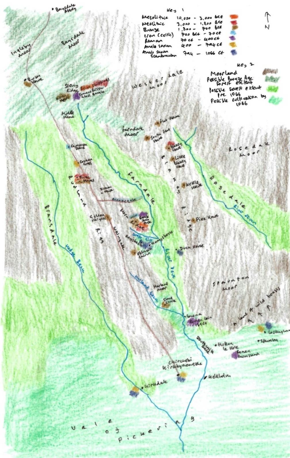
In Map 2, Key 1 is a colour
code for archaeological finds around Farndale and the period of time with which
they are associated, giving an indication of settlement patterns around
Farndale through time. Key 2 shows the possible extent of moorland, woodland up
to the Bronze Age and woodland up to 1066 and beyond, and the area of
cultivation at the edge of the Vale of Pickering.
Stony Ridge
To the immediate
north of Farndale, Stony Rigg is a site of Mesolithic and Neolithic activity.
The first trace of early man in the Farndale district comes from
the high moors at the dale head. On the bleak uplands of Stony Rigg, 1300 to
1400 feet above sea level, wherever the peat has eroded away, scatters of flint
chippings are found. These are in distinct groups, usually near a spring or
rivulet of water. They are called microliths as the worked implements are
usually tiny triangular points or long rods. Many larger utilised flakes, used
for knives etc, are also found, as well as round or oval scrapers. (Raymond Hayes, Farndale, 1961, unpublished, page 4).
The archaeology reveals a mix of activity from the Mesolithic through
to the Bronze Age. The area was likely to have been forested until the Bronze
Age.
There is evidence that forest had once spread across the high ground as well as
through the dales (Professor G W
Dimbleby, The Ancient Forest of Blackamoor, Antiquity, Volume 35/138,
June 1961, pages 123 to 129). Oak was predominant, with alder, hazel and birch
scrub. Dimbleby thought that it was early flint users who were responsible for
the initial felling of this forest.
No dwelling or burial ground of these flint users has yet been
found in northeast Yorkshire, but the flints are plentiful on certain parts of
the moors. The nearest site where similar flints are found is Star Carr in the peat bogs of the vale of Pickering, near Starmer.
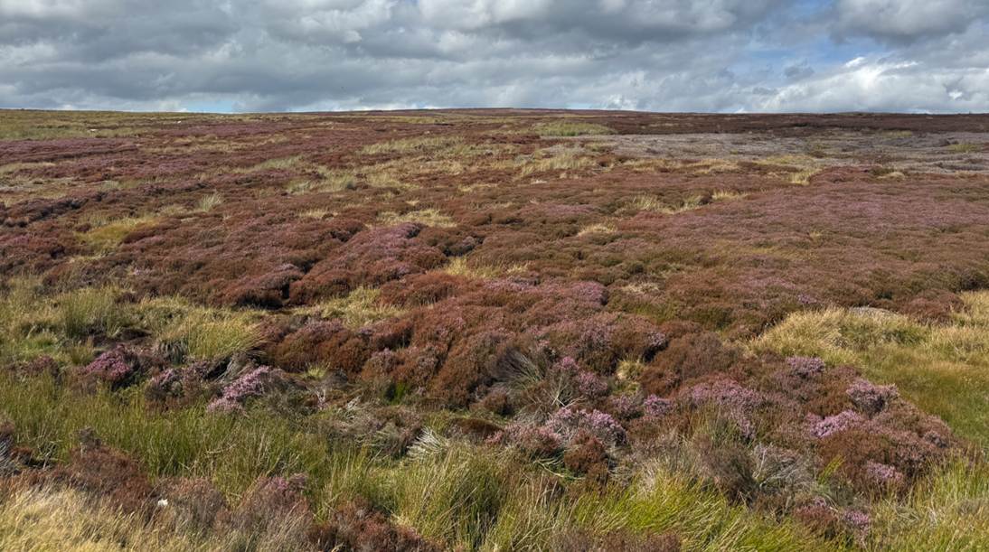
Stony Ridge, August 2025
A kind of triangular, broad, transverse arrowhead was used by the
Mesolithic folk, and the sharp, needle like points. The bow was used from a
very early period, certainly at Star Carr. The Neolithic or New Stone Age came
in gradually and by 5,000 years ago we have evidence of hunters equipped with
superior arrowheads of leaf shaped flints, beautifully worked as examples found
by a gamekeeper at Great Howdale above Gill Wath
shows. Many birch leaf shaped arrowheads are found near the dale sides.
Flint and stone axes were used to fell forests. Examples have come
from Stony Rigg and in the dale itself. There is an early example in
Middlesbrough museum and a fine polished stone axe of the Lake District.
Volcanic slate was found at Lowna Mill in the lower
part of the dale. The four unused tanged and barbed arrowheads belong to the
early bronze age and were lost together in a quiver about 3,500 years ago on
Stony Rigg to be found under two inches of peat by Walter Thornley in 1953.
(Raymond Hayes, Farndale, 1961,
unpublished, page 4 to 5).
Dr G W Dimbleby has examined the peat on Farndale head and Westerdale
head near Stony Rigg and he found pollen of forest trees – oak, hazel and
alder. This forest must have existed at least 5,000 to 7,000 years ago and was
felled or fired by flint users, termed Mesolithic or Middle Stone Age folk.
They were probably like modern Eskimo or Lapp reindeer herdsmen and huntsman.
They seem to have been nomadic in habit, living in skin tents of flimsy turf or
wooden huts which have left little or no trace. All the flint was brought from
the coast of east Yorkshire wolds; none is local (Raymond Hayes, Farndale, 1961,
unpublished, page 4).
Historic England AO2029 comprises original drawings of implements, flakes and chippings found
at the Stony Rigg Mesolithic site drawn by R H Hayes in 1952 to 1953, with
accompanying key on a separate sheet.
Three Howes
Near Ouse Gill Head on Rudland Ridge at the Three Howes
(SE 63209 98210), flint tools had been found by the gamekeepers over a number
of years. In September 1973 Raymond Hayes and others excavated the area. His
excavation work found over 800 flints from an area of 3.5m x 3.0m (Old Roads & Pannierways
in North East Yorkshire.
R. H. Hayes.1988], Raymond H Hayes, Escaping the Mad Parade in the Smell of
Water). The site was interpreted as a
temporary camping site in a forest clearing, probably being occupied by hunters
following red deer or other game.
Dove Bank
Historic Environment Record 10295
(North York Moors HER Records), an assemblage of
Mesolithic worked flint and flint tools collected over a number of years and
may represent material from an occupation site which is being spread by
ploughing and hillwash.
Go forward to Neolithic Yorkshire.
Bibliography
A
History of Helmsley Rievaulx and District, editor, J McDonnell, 1963.
Early Mesolithic
Activity in the Wetlands of the Lake Flixton Basin, Barry Taylor,
2013.
Farndale, Raymond Hayes, 1961,
unpublished.
The Ancient
Forest of Blackamoor, Professor G W Dimbleby, Antiquity, Volume 35/138, June 1961.
The Mesolithic
Period in northeast Yorkshire, J Radley, Yorkshire Archaeological
Journal Volume 42, 1966, page 314.
A look at Ryedale Settlement Patterns, Ryedale Historian, Volume 12, 1984, page 31.
Prehistoric Environments, R.L. Jones et al in Spratt’s The Prehistoric and Roman Archaeology of North East Yorkshire, 1982.
Yorkshire Archaeological and Historical
Society – Mesolithic Yorkshire.
There
is an In Our Time podcast on Doggerland.