The vicinity of Farndale in the Neolithic Period, the New Stone
Age (3,000 BCE to 1,800 BCE)
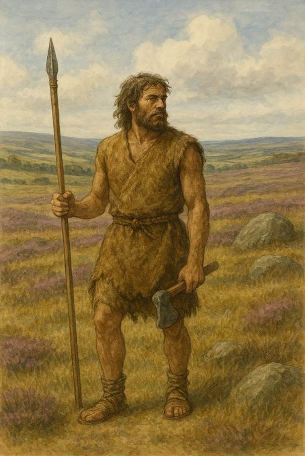
Early
agriculture and a period when nomadic folk met groups who started to settle and
cultivate the land
FAR00001D
|
Return to the Home Page of the Farndale Family
Website |
The story of one family’s journey through two
thousand years of British History |
The 83 family lines into which the family is divided.
Meet the whole family and how the wider family is related |
Members of the historical family ordered by date of
birth |
Links to other pages with historical research and
related material |
The story of the Bakers of Highfields, the Chapmans,
and other related families |
Dates are in red.
Hyperlinks to other pages are in dark blue.
Headlines are in brown.
References and citations are in turquoise.
Context and local history are in purple.
BCE - Before the common or current era. The contemporary equivalent of
BC.
CE - Common or current era. The
contemporary equivalent of AD.
Go back to Mesolithic
Yorkshire.
Context - The New
Stone Age
The New Stone Age was the period when tool making skills produced
stone axes, flint axes, arrow heads, and spear points. This was a revolutionary
advance in the cultural evolution of northeast Yorkshire and occurred there in
around 3,000 BCE. This was a period when the first Neolithic settlers arrived
from the Continent, presumably crossing in boats such as dug
out canoes. The Neolithic Revolution introduced arable farming and the
domestication of animals. Communities no longer lived a semi nomadic existence.
Permanent settlements were built, such as at Ulrome, between Hornsea and
Bridlington, where a dwelling built on wooden piles on the shore of a shallow
lake has been excavated.
10,000 BCE
The beginnings of agricultural practice in different regions has been
dated from 10,000 to 8,000 BCE in the Fertile Crescent (that is the crescent the lower Euphrates through Mesopotamia and
bending back down along the Levant); perhaps 8,000 BCE in the Kuk Early
Agricultural Site of Papua New Guinea in Melanesia; and perhaps 9,000 BCE In
South America.
In the Neolithic Revolution, agriculture supported bigger communities,
with more offspring, with a better chance of survival of the whole group. As
well as cereals, farmers also started to domesticate cattle and sheep.
The process also started to alter human perception of who we were, from
a part of the natural world during the Mesolithic to more complex communities,
with evolving ideas and religious beliefs. This was a profound revolution in
the human story.
By 5,000 BCE the
Neolithic Revolution was spreading through southern Europe.
In Britanny, the unique
collection of standing stones at Carnac, carefully aligned with the unique
geomorphology of the landscape, dates from about 4,900 BCE. They were erected
by Mesolithic hunters at the time that Neolithic farmers started to appear to
the south. Carnac seems to represent a clash between cultures; the monumental
scale of the alignment of stones might have been a demonstration of strength in
the face of a different people they didn’t understand. In a few generations
this generation of the old world would be subsumed into the new.
It was at this melting
point between the old world, and the introduction of agriculture, that
Neolithic stone tombs started to appear. This was accompanied by remarkable
rock art. At the melting point at sites such as Carnac, the transition between
the Mesolithic and Neolithic worlds was reflected in the rock art.
4,500 BCE
By 4,500 BCE the
Neolithic Revolution had spread across Continental Europe, but had not yet
crossed the barrier of the Channel to Britain. It would take hundreds more
years before it reached Britain.
4,300 BCE
It is possible that the
Neolithic Revolution first reached Ireland by about 4,300 BCE.
Evidence of vole skulls
also suggests the early arrival of Neolithic farming in Orkney. The Orkney Vole
species is related most closely to voles of the Rhine valley. The voles
probably arrived amongst grain carried by early farmers direct from Germany or
France.
There seem to have been
multiple routes to Britain, as well as a later more direct route to Kent.
3,985 BCE
The first Neolithic
families to mainland Britain must have been pioneers crossing by boat with
their families, and with seed and livestock, to an unknown land.
Evidence of some of the
first Neolithic farmers is found at the Coldrum Long Barrow in Kent, which dates to
about 3,985 to 3,855 BCE. This is a thousand years earlier than Stonehenge.
About 22 individuals were interred in the Coldrum
tomb. They were probably close family members.
Nothing like this had been
seen in Britain before. These were Britain’s first farmers. They found woodland
when they arrived, so, watched by wary Mesolithic hunters, their first task was
to clear the forest for their settlement and fields. Whilst Mesolithic hunters
had tended to hug the coastline areas, these first farmers started to break
into the interior of Britain. By this time forest blanketed the landscape of
Britain, where red deer, boar and bears lived. The Neolithic farmers started to
shape the land, to control it.
The Neolithic Revolution
seems to have spread across Britain in a few generations.
3,650 BCE
West Kennet Long Barrow at Avebury in Wiltshire,
is one of the largest and most impressive Neolithic graves in Britain, dating
to about 3,650 BCE. It was used for about a thousand years and the bones of
selected individuals were placed in an organised way, but mixed together to
represent the collective ancestors rather than particular individuals. The
tombs were left open, so they seem to have been temples to commune with the
dead. Ancestors were an active part of the social group. The barrow was the
work of a whole community. Busy farmers expended considerable resource to
create a kingdom for their dead, but also to mark out the landscape which was
theirs. The link between the community, ancestor and agricultural fields,
marked a claim to ownership of the land.
Early evidence of armed
conflict is found at Crickley Hill in Gloucester, a
strategic hill top important to control of the surrounding land, where a series
of violent events occurred over thousands of years, including an attack around
3,600 BCE on a Neolithic causewayed enclosure (also the location of a later battle
in the 6th century BCE that destroyed an Iron Age hillfort). Evidence includes
hundreds of flint arrowheads found at the site, burnt structures, and the
remains of a defensive wall. Conflicts were fought using Neolithic bows. These
conflicts are significant for being among the earliest evidence of organised
warfare in Britain.
3,500 BCE
The Céide Fields is an archaeological
site on the north County Mayo coast in the west of Ireland. The site has been
described as the most extensive Neolithic site in Ireland and is claimed to
contain the oldest known field systems globally. It comprises perhaps 100 linear
kilometres of stone walling, cattle enclosures stretching across the landscape,
for herd management such as weaning calves. Using various dating methods, the
fields were built around 3,500 BCE, some 2,500 years before this type of field
system developed everywhere else in Europe.
From Neolithic
communities, ideas of societies evolved, bound together for a common purpose.
From about 3,600 BCE huge prehistoric monuments appeared in the Megalithic
Period. The organisation required to
erect the large megalithic structures suggests highly developed society. Stonehenge Cursus dated to about 3,500 BCE
is a large Neolithic cursus monument on Salisbury plain, near to Stonehenge in
Wiltshire. It is roughly 3 kilometres long and 150 metres wide. Named cursus
as these sites were originally thought to have been Roman racetracks, they are
vast sites which would have taken monumental effort to construct, of unknown
purpose, perhaps land boundaries or processional sites.
Causewayed enclosures,
such as at Larkhill, are Neolithic
earthworks marked out by ditches and banks, associated with multiple artefacts,
which were likely to have been meeting places for large gatherings, evidencing
the evolution of society.
Small village communities
became settled, more reliant upon domestic animals and less on hunting. They
built stone enclosures for animals, and developed rituals for the dead and
forms of religion. Burial was often in caves and in stone lined graves.
The development of
grinding and polishing stone allowed a variety of stone as well as flint to be
used. Hard boulders from local glacial deposits were useful raw material.
3,200 BCE
The Newgrange Passage Tomb, north of Dublin, was
constructed in about 3,200 BCE, predating the Orkney stone circles and
Stonehenge as well as the Pyramids of Egypt, and may represent the origin of
the tradition of megalithic structures. It may have been the inception of
megalithic ambitions. It is carefully aligned with the movement of the sun, the
sun aligning with a triple spiral carving in the depth of the tomb.
Knowth Passage Tomb also dated to about
3,200 BCE with evidence of the earliest ritual cremation in the remains of
about a hundred burnt bodies found in the tomb, in rituals which lasted over a
period of about three hundred years. The new practice of cremation was therefore
unusual and suggests it was an honour for a higher, perhaps priestly, class, to
be sent to somewhere different from those left behind on earth, to the skies
and perhaps an early conception of the heavens.
3,100 BCE
Stonehenge was constructed in
several phases beginning about 3,100 BCE and continuing until about 1,600 BCE.
The famous circle of large sarsen stones were placed between 2,600 BCE and
2,400 BCE. The surrounding circular earth bank and ditch, which constitute the
earliest phase of the monument, have been dated to about 3,100 BCE. Radiocarbon
dating suggests that the blue stones were given their current positions between
2,400 and 2,200 BCE, although they may have been at the site as early as 3,000
BCE. The Sarsen stones were from relatively close to the monument but the
original smaller freckled blue stones were from the Preseli Mountains in Wales.
Stone circles are
virtually unknown outside Britain and Ireland, but there are significant
numbers across those landscapes, often in the most dramatic locations.
The largest standing stone in Britain is a single pillar of
grindstone, nearly 8 metres high. It dominates the churchyard at Rudstone, a few miles west of
Bridlington, East Riding of Yorkshire. The nearest source of stone is 10 miles
north of the site. Many other prehistoric monuments in the area include four cursuses, three of which appear to converge on the
site of the monolith.
The farmers were probably supporting a priestly class. There may have
been connections between the monuments across Britain, suggested by the
distribution of a pottery style found at different monuments. Individuals may
have travelled between monuments across the British Isles by boat, spreading
ideas, and trading objects, between communities. Such trade is exemplified by
the Knowth macehead (c 3,300 to 2,800 BCE)
at Newgrange in Ireland which perhaps originated in Orkney or mainland Britain.
This was a connected world. It was the forum for an early elite of religious
leaders to emerge.
3,000 BCE
The communities on Neolithic Orkney were building enduring
stone tombs, large stone circles, and impressive domestic homes, including the
sites at Skara Brae, the Ring of Brodgar, the stones of Stenness, Dwarfie Stane, Unstan Chambered Cairn, Maes Howe Chambered Cairn, the Tomb of the Eagles. Maes Howe is aligned with two hills on the neighbouring island of
Hoy and in mid Winter the setting sun shines through
the passage to light up the inner chamber, revealing a connection with the
cosmos. The Ring of Brodgar (c 2,500 BCE), one of the largest stone circles, is
also associated with the Maes How landscape. The scale of the Ring of Brodgar
was impressive, with a 10m x 3m ditch cut into bedrock surrounding the circles
which alone may have taken a hundred string workforce six months to construct. The
Ring seems to be a portal across a land bridge to an older stone circle, the
Stones of Stenness (c 3,000 BCE), also aligned with
Maes Howe. This was landscape architecture on an epic scale. It was strongly
associated with the cosmos, searching for the human place in the heavens.
The sun aligns with the Maes How tomb for roughly six weeks around the
winter solstice, from late November to mid January
and the best chance of seeing the sun illuminate the chamber, is on the 2 pm
tour around midwinter
The revolutionary advance and the cultural evolution of New Stone Age
occurred in around 3,000 BCE in northeast Yorkshire.
In the Wolds, where the lighter soils made clearing the land easier,
communities worked together to mark some of their dead with the cigar shaped
mounds of chalk known as long barrows. Most have now been ploughed out, but the
one excavated at Willerby Wold had a conclave fore
court where burial rituals took place before the dead were laid in a wooden
chamber. The whole thing was then covered with a chalk mound and burned. (The
Little History of Yorkshire,
Ingrid Barton, 2024, page 15).
The Neolithic Revolution was also associated with the introduction of
new technology including querns for grinding grain and pottery. The lifestyle
of the new Neolithic farmers may not have been as healthy as the varied diet of
the Mesolithic hunters and involved the daily grind of monotonous work
such as grinding grain, albeit the hunters were more susceptible to drought and
scarcity. The productivity of farming, and the potential for surplus, was the
driving force.
The Neolithic also introduced new ideas of land ownership, which
brought conflict.
This was an intersection in Yorkshire’s story when the wild world,
with which the Mesolithic hunters had been so in tune, became a dangerous place
contrasted to the safety of homeland landscapes, from which the new farmers
were separating.
This was also a period of an evolution in spiritual and religious
ideas, and of a more formal association with the sun and the stars.
2,500 BCE
The Sudenkirk or Swinside Stone Circle, in the lowlands of the
Lake District below the Langdale axe factory, was another example of the
megalithic tradition that lasted from 3,300 to 900 BCE. Communities were making
spiritual connections between the landscapes, communities and the cosmos.
Durrington Walls (c 2,500 BCE) near Stonehenge was an ancient site of winter
gathering, adjacent to a village, probably a place of the commemoration of
ancestors, associated with Stonehenge.
About 2,500 BCE, Neolithic farming communities built three vast,
identical circular earthwork enclosures or henges at Thornborough, about 10 km west of Thirsk. As one of the largest acts of
building ever undertaken by later Neolithic communities, they are testament to
the poignancy, intensity and power of religious belief and practice during the
third millennium BC. Yet their significance goes beyond their scale, for they
are part of a remarkable cluster of at least eleven similarly-designed and
comparably-sized henges. These monuments are more than simply northern English
counterparts to the better known sites of the Wessex chalkland, for they
challenge the assumption that henges are the religious ‘capitals’ of
distinctive social entities, highlighting instead a more nebulous and complex
system of relations and identities. (Neolithic
Identity and the Henge Monuments of Yorkshire, Dr Jan Harding, Lecture to the Prehistory Research Section, Yorkshire
Archaeological and Historical Society).
2,400 BCE
Silbury Hill near Avebury is an artificial
chalk mound and the tallest prehistoric man made mound
in Europe, constructed in stages between about 2,470 to 2,350 BCE by multiple
generations. It may have been one of the last of the great Neolithic monuments
before the arrival of the Beaker Folk and the metals they brought with them.
Neolithic sites in
Farndale
Although the various
cultures of the Stone and Bronze Ages are divided into phases for approximate
dating purposes, much overlap must have taken place. (A
History of Helmsley Rievaulx and District,
editor, J McDonnell, 1963,
page 10).
A circular area six miles in radius with the centre at Helmsley was
chosen and it was decided to analyse the change in settlement patterns between
the Mesolithic (beginning 7600 B.C.) and the Domesday Book (1086). The
programme of investigation began with the mapping of settlement sites for each
of the six periods.
The Neolithic and Bronze Ages saw the first permanent settlements as
man settled down and learned how to farm. However, none of these early
settlements have survived or been discovered yet and we are forced to imply
their position from the surviving stone burial mounds (or barrows ).
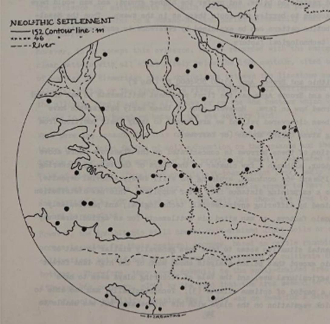
The distribution of these barrows is concentrated on the limestone
moors above the 152m contour, although a few cluster on the clays of the Vale
of Pickering between the 152 and 46 m
contours, avoiding the still swampy alluvial deposits, and sometimes a
surprising distance from water supplies. This new distribution can be explained
by differing environmental, technological, and particularly the new economic
factors, as man sited his settlements for an agricultural way of life.
The environmental situation seems to have been generally similar to
that of the Mesolithic except that pollen analysis shows much of the high land
forest cleared for agricultural use, and the Vale of Pickering clays seem to
have dried out in a period of optimum climate (3). Technologically, man was
able to clear the thick vegetation on the clays with his bronze axes but was
unable to plough the alluvium due to its swampyness and the light weight of his primitive plough.
He thus settled on the clays and the high ground overlying the oolites
as these areas gave him the light, dry agricultural land he needed for a mixed
pastoral/arable economy rearing pigs, sheep and cattle, and growing cereals
(although the latter would only have been successful up to an altitude of
300m). The distance of some of the sites from water is perhaps explained by the
fact the barrows were probably meant to be seen from some distance (as either a
monument or boundary marker) and so placed on top of hills, while their
respective settlements were probably nearer the water supply, further down the
valleys. Alternatively the era could have been one of social upheaval and the
defensive qualities of sites put before that of convenience.
(A look at Ryedale Settlement Patterns, Ryedale Historian, Volume 12, 1984, page 31)
It is now axiomatic that we may look for early settlements of man, on
naturally bare and treeless ground. There it was easiest to move about; there
we may find the earliest routes; there it was easiest to control herds and
break the ground. The chalk capped wolds in Yorkshire
are just such an area, and here in fact we find the thickest remains of the
Neolithic and Bronze Ages. Further, this area is accessible as it touches the
sea and the Humber; and across the Humber faces the Lincolnshire Wolds and the
Lincoln Ridge, a terrain which is also bare and treeless.
As Dr Fox and Mr Elgee have shown, in Neolithic times and in the early
Iron Age respectively, Yorkshire was in close touch with south-east England
along the line which includes and extends the Lincoln Ridge, that Dr Fox
christens the Jurassic Zone.
If the early settlers on the wold
multiplied, and wished to expand, they were separated from the rest of
Yorkshire by two low lying and naturally swampy plains, the Vale of York to the
West and the Vale of Pickering to the north. It is possible to circumvent the
Vale of Pickering by the slightly higher ground towards the coast on the east,
and by the low range of the Howardian Hills to the west. But, as Mr Elgee has
convincingly shown, while the limestone fringe of the North Yorkshire Moors has
always attracted settlers, the inner heights are not merely bare but
particularly barren, and have only been used as a refuge.
(Some Invasions of Yorkshire, Mary Kitson Clark, Yorkshire Archaeological Journal,
Volume 31, page 320).
The evolution of human thinking
Sander van
der Leeuw has identified the real significance of the evolution of
neolithic tool making in expressing the new cognitive ability of the human
brain. The simplest early tools had natural points and edges. Our Palaeolithic
ancestors then learned to create a sharp edge, by flaking off part of the stone
by hitting it against another surface. On a global scale it was by about 20,000
YPB that they then started
to create tools with multiple flaked edges, with the new technology spreading
more recently in places like the moors. Our ancestors mastered tool making in
three dimensions, by removing flakes at specific angles to create sharpened
points, involving the intersection of three planes. Early stone tool making
found its ultimate expression in the Levallois Technique,
which involved mental reasoning and understanding of multiple stages in making
a tool. This ability emerged from the increased cranial capacity of the human
brain from about two million years ago, which in turn expressed a new uniquely
human ability for planning and long term thinking. Van der Leeuw found advances
in stone knapping
techniques reflected a step change in the human mind.
In other words these very earliest expressions of human activity
on the edge of Farndale, are representative of a global evolution of humans
into thinking, reasoning and forward thinking people.
Agriculture
Three varieties of wheat, all derived from
wild species – einkorn, emmer and bread-wheat – were cultivated in Neolithic
times by the first settled farming communities. Two
grains of carbonised wheat resembling emmer were found embedded in an early
Bronze Age vessel at Hanging Grimstone in the Yorkshire wolds.
The first domesticated animals were cattle, sheep and pigs: the dog had been
tamed long before by the hunters and food gatherers. First the ground had
to be cleared of forest. We have hints that fire played a major part in this
process during Mesolithic times, but the earliest remains of the Neolithic
Ryedale farmers are several flint and stone axes. Unlike the earliest types,
they are usually highly polished. (A History of Helmsley Rievaulx and District, editor, J McDonnell, 1963, page 11).
Pottery
Some time in the 3rd or 4th
millennium BC, the first people to make pottery and cultivate wild plants
spread gradually into Britain from eastern and southeastern Europe. The
earliest pottery from the Continent may have been brought over by the food
gathering ‘kitchen-midden’ folk of late Mesolithic times. They gathered vast
quantities of shell-fish which they ate, and dumped the shells in great
‘middens’ (refuge heaps) around their dwellings, of which little trace remains.
The pots were of a black, gritty fabric, a ware that persisted throughout the
succeeding periods, and they were cook pots with rounded or pointed bases which
had to be supported with stones. (A History of Helmsley Rievaulx and District, editor, J McDonnell, 1963, page 10).
Neolithic Farndale
Neolithic
microlith sites have been found on the moors at Bransdale and Farndale
including flint and stone chippings and basic tools. The surrounding heights on
Westerdale and Rudland Rigg provide some of the richest flint tool sites in
Britain (The Mesolithic
Period in northeast Yorkshire, J Radley, Yorkshire Archaeological Journal
Volume 42, 1966, page 314). Petit
tranchet microliths or arrowheads, have been found at the Farndale
sites.
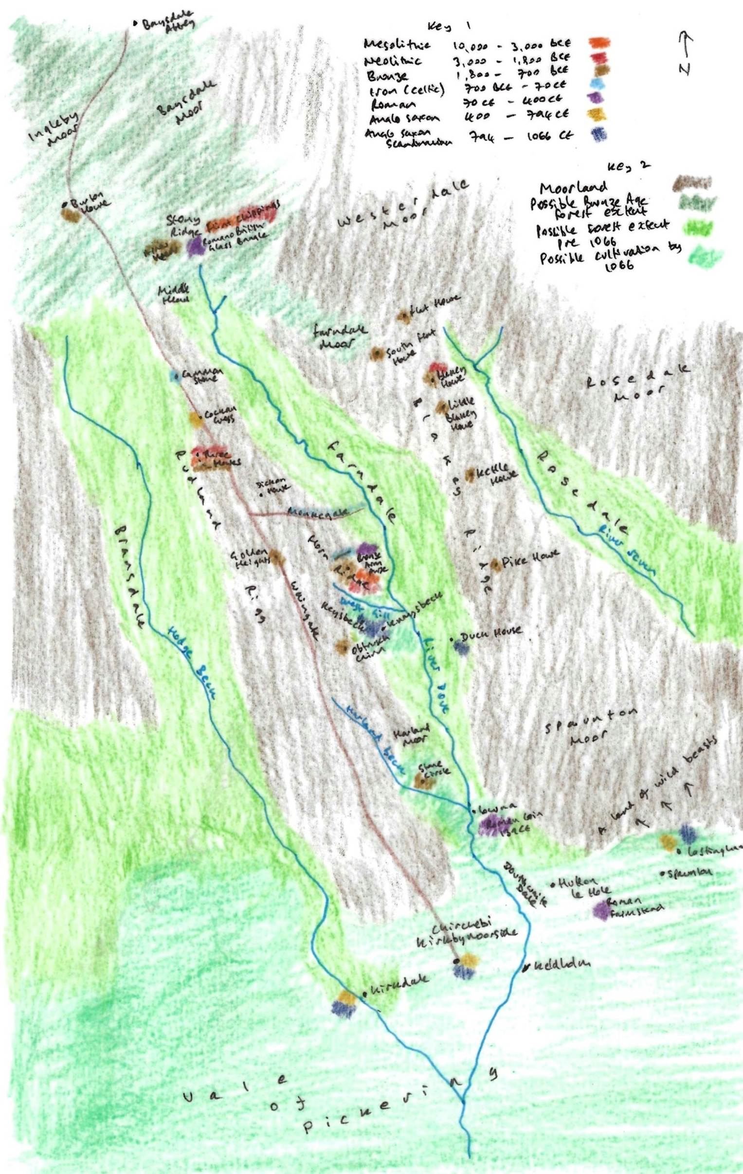
A
representation of Farndale and its vicinity prior to 1066
Key 1
is a colour code for archaeological finds around Farndale and the period of
time with which they are associated, giving an indication of settlement
patterns around Farndale through time. Key 2 shows the possible extent of
moorland, woodland up to the Bronze Age and woodland up to 1066 and beyond, and
the area of cultivation at the edge of the Vale of Pickering.
It is
notable that microlithic sites are almost all above 1,000 feet above sea level.
They include:
· A
site on Blakey Ridge at SE 679995 south of the Lion Inn;
· A
site on the west ridge of Bransdale on rocky and peaty ground at SE 606974 and
SE 608975;
· The
scatter of chippings and long flakes north east of the Cammon stone at SE
627000;
· A
site at Cockan Top at SE 613007;
· A
site at Eskletts on Farndale Moor at NZ 666007; and
· A
site across Farndale dalehead and Farndale moor
between NZ 630022 and NZ 664008.
Flint
and stone axes and other implements are also prolific. Flint axes are rarer
than those of stone. All flint was brought to the district from the coast.
The
earliest type was the tranchet, with a cutting edge formed by the intersection
of two or more flake surfaces. They are often crudely flaked and unpolished.
There is an axe of this type from Farndale in the Middlesbrough Museum, though
its exact site is not recorded. It is light buff to yellow and about 4 inches
long.
Polished
flint axes are more plentiful. There is a partly polished flint with a round
blade and square butt from above Farndale at the Hull Museum Featherstone
collection. There was also a polished blade found at Lowna
in Farndale (SE 686907) found by J Baxter in 1890.
Stone
axes are more abundant. There are polished stone axes, one with with a rounded
butt and blade, from above Farndale in the Hull Museum and another polished
greenstone from Lowna Mill Field (SE 685906) which
was in the possession of Raymond Hayes. Others have been found at Beadlam, Harome and Kirkbymoorside.
(A
History of Helmsley Rievaulx and District, editor, J McDonnell,
1963, page 336 to 343).
Frank
Elgee commented that early man did not find material within rocks that they
valued except for jet. Jet has been known in East Yorkshire since Neolithic
times. Jet rock is found in the upper parts of Bilsdale, Bransdale, Farndale
and Rosedale. (Early Man in Northeast Yorkshire,
Frank Elgee, 1930, page 108).
Go forward to Bronze Age Yorkshire.
Bibliography
Yorkshire Archaeological and Historical Society – Neolithic Yorkshire.
A
History of Helmsley Rievaulx and District, editor, J McDonnell,
1963.
Early
Man in Northeast Yorkshire, Frank Elgee, 1930.
A look at Ryedale Settlement Patterns, Ryedale Historian,
Volume 12, 1984, page 31