Richmond and Gilling West
Historical and geographical information
|
Return to the Home
Page of the Farndale Family Website |
The story of one
family’s journey through two thousand years of British History |
The 83 family lines
into which the family is divided. Meet the whole family and how the wider
family is related |
Members of the
historical family ordered by date of birth |
Links to other pages
with historical research and related material |
The story of the
Bakers of Highfields, the Chapmans, and other related families |



Dates are in red.
Hyperlinks to
other pages are in dark
blue.
Headlines are in brown.
References and
citations are in turquoise.
Contextual
history is in purple.
This webpage
about the Richmond has the
following section headings:
· Overview
· Timeline
· Gilling West
· Bibliography
The Farndales of Richmond
The Richmond Line are the
descendants of William Farndale (FAR00531) 1875
to 1948 who was a farmer of Gillingwood Hall.
Richmond
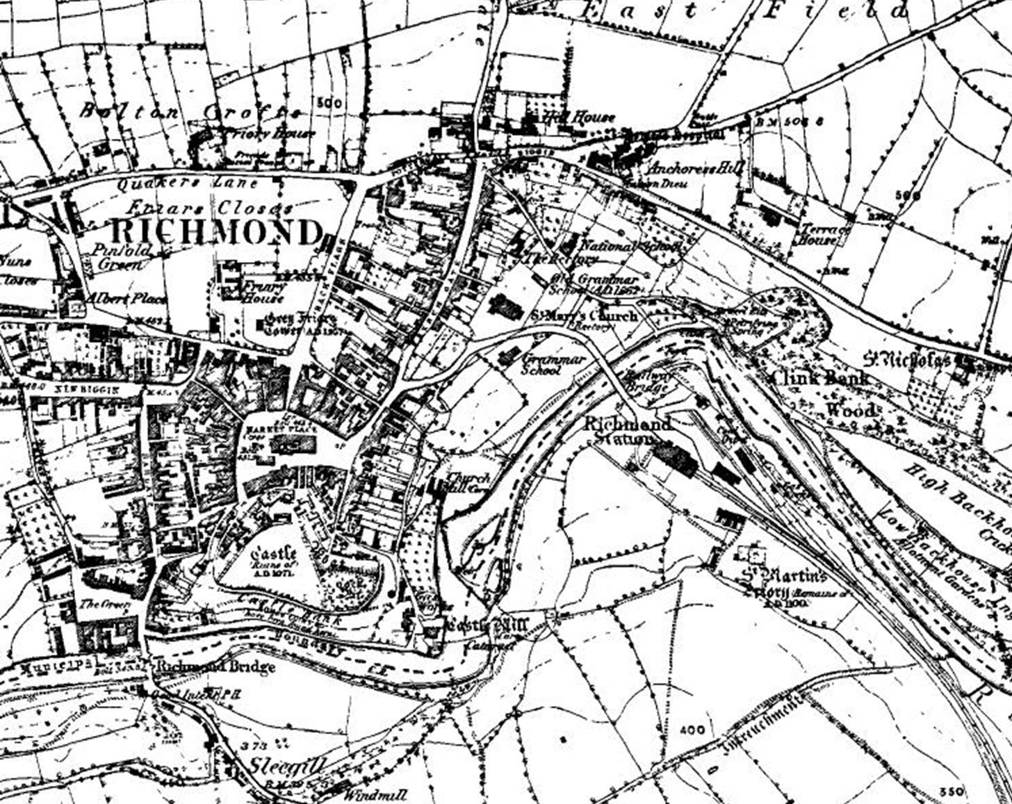
Richmond is a market town and
civil parish in the district and county of North Yorkshire. It is in the
Swaledale valley, near the River Swale, and on the eastern edge of the
Yorkshire Dales National Park.
The town of Richemont, in Normandy
was the origin of the place name Richmond.

Richmond Timeline
1071
Richmond was
founded in 1071 by Alan Rufus, a Breton nobleman, on lands granted to him by
William the Conqueror, though it was called Hindrelag initially.
1086
In the Domesday
Book of 1086, the area was collected under Yorkshire, the town was in the
Gilling Wapentake. After this, it became the centre for wapentakes in the
Honour of Richmond for the North Riding of Yorkshire.
Richmond Castle
was completed in 1086 with a keep and walls encompassing the area now known as
the Market Place.
Richmond was part
of the lands of the earldom of Richmond, which was intermittently held by the
Dukes of Brittany until the 14th century.
1322
Richmond is one
of a few settlements that was spared from being raided by the Scots during The
Great Raid of 1322 by bribing them off.
1399
John V, Duke of
Brittany, died in 1399, and Henry IV took possession.
1453
In 1453, the earldom
was conferred on Edmund Tudor, and it was merged with the crown when Edmund's
son became King Henry VII in 1485. During the Wars of the Three Kingdoms, the
Covenanter Army led by David Leslie, Lord Newark, took over the castle, and
conflict ensued between local Catholics and Scottish Presbyterians.
1608
In 1608, Robert
Willance became the first alderman of Richmond. Two years before that in 1606,
whilst hunting on the nearby Whitcliffe Scar, the horse Willance was riding
became nervous when thick mist descended, bolting over the edge and falling
over 200 feet to the valley floor, Willance survived this fall with a broken
leg and erected a monument on top of the cliff as a show of gratitude for his
survival. Willance died in 1616.
Eighteenth
century
The prosperity of
the medieval town and centre of the Swaledale wool industry greatly increased
in the late 17th and 18th centuries with the burgeoning lead mining industry in
nearby Arkengarthdale. It is from this period that the town's Georgian architecture
originates, the most notable examples of which are to be found on Newbiggin and
in Frenchgate.
1830
One of Europe's
first gas works was built in the town in 1830.
1857
1877
A permanent
military presence was established in the town with the completion of Richmond
Barracks in 1877.
1915
During the First World
War, Richmond's own Green Howards Regiment raised 24 battalions for the war
effort, the castle assumed a role as a barracks and training camp for new
recruits and members of the Non-Combatant Corps, in 1915, the first troops
occupied the area south of Richmond in what was to become Catterick Camp, the
planning of which was commissioned by Lord Baden Powell during his residence at
the town's barracks.
1916
In 1916, a group
of "absolutist" conscientious objectors known as the Richmond Sixteen
were held at the castle after refusing to undertake even non-combatant military
duties. After being transported to France, they were court-martialled and formally
sentenced to be executed by firing squad, but this sentence was immediately
commuted to ten years' penal servitude, and the men were eventually released in
1919.
Richmond Castle's
19th-century cell block continued to be used to house prisoners into the Second
World War.
1927
In June 1927,
Richmond was a centre line of totality during a solar eclipse, the event is
marked with a plaque at the top of Reeth Road.
Gilling West
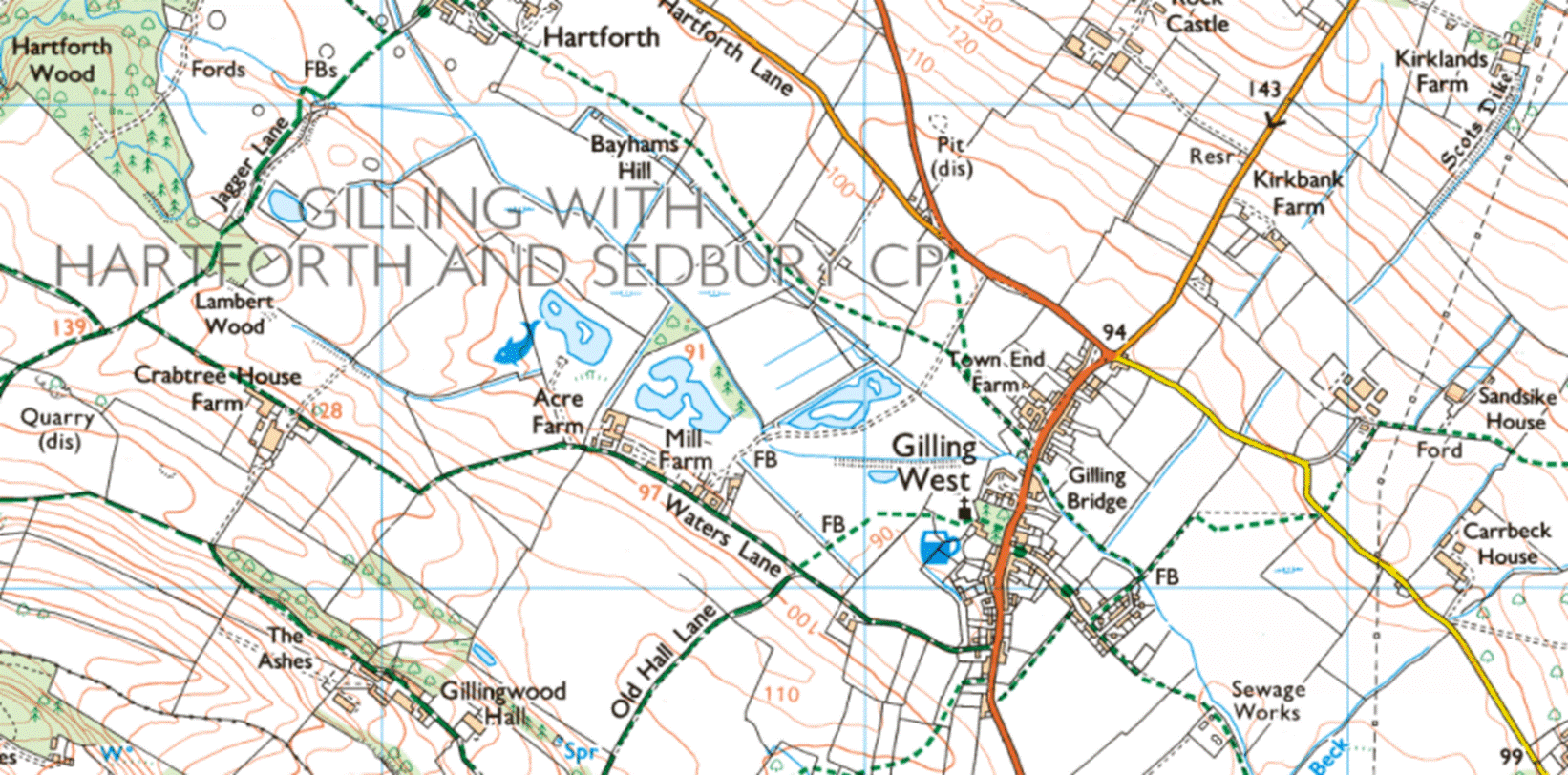
Gilling West is a village
about 3.5 miles north of Richmond in
the Richmondshire district of North Yorkshire. It is located in
the civil parish of Gilling with Hartforth and Sedbury.
Anglo
Saxon period
Gilling was once a place of some
importance in the Anglo-Saxon period of British history. In the 7th
century it was a seat of the Deira in the southern region of the
Anglican kingdom of Northumbria.
The Victoria County History – Yorkshire, A History of
the County of York North Riding: Volume 1 The wapentake of Gilling West, 1914: Gilling was always said to
have been the Ingetlingum of Bede, where Oswiu king of Deira was slain by Oswi
king of Bernicia; but the scene of Oswiu's death and the site of the expiatory
monastery raised by Eanfled has now been shown to be Collingham, 6 miles from
Barwick in Elmet in the West Riding.
Gilling was, however, the chief
seat of Edwin Earl of Mercia, and possibly for a time the head of the castlery
(castellaria) of Count Alan, though the day of its greatness was already over
in the 12th century; this stronghold may have stood on 'Castle Hill.'
A quarter of a mile beyond the
parish boundary is Scotch Corner, and the earthwork which is to be seen south
of the village, and again for nearly half a mile to the north, is known as
Scot's Dike. From Scotch Corner a branch of Watling Street cuts through the
north of Gilling parish on its way to Barnard Castle. It skirts the extensive
woods of fir, pine and larch adjoining Sedbury Park and Hall, and crosses the
road that runs from Richmond to Lucy Cross through Gilling. At this point the
land reaches a height of 605 ft., and a fine view is commanded over Gatherley
Moor (now cultivated land) to the north; Gilling lies 300 ft. below in the
valley, with the woods and hills of Aske to the south. Further on the Roman
road is crossed by the high road that runs from Richmond to Staindrop through
Gilling. The hamlet of Hartforth lies in a well-wooded valley by Hartforth
Beck. Jagger Lane, one of the oldest roads in the country, connects the
Hartforth lead mines with Watling Street. A road runs from South Cowton through
North Cowton to Yarm, and is joined at Atley Hill by the road from Catterick
Bridge to Yarm.
Ninth
century
From the 9th century, the
surrounding area known as Gillingshire was ruled by the Earls of
Mercia, specifically Edwin, who was the last of the Earls to have a seat
of power at Gilling. In April 1976 nine-year-old Garry Fridd found a sword in
the beck while playing close to the bridge in Gilling. It turned out to be a
double-edged, iron-bladed sword with a silver-decorated handle, dating from the
9th century. It is regarded as being amongst the best Anglian weapons ever to
be discovered in England. The restored Gilling sword is in the
collection of the Yorkshire Museum in York.
1086
Gilling was mentioned in
the Domesday Book under the name of Ghellinges. before
the Norman Conquest saw Edwin's lands given to William the
Conqueror's kinsman, Alan Rufus. There were 16 villagers, 3 freemen and 6
smallholders and the tenant-in-chief was Count Alan of Brittany.
The parish church is dedicated to
St Agatha. The Domesday Book records a place of worship in the village as of
1086. The Church of England
website comments that "it is
mentioned in the Domesday Book and parts of St Agatha’s date back to this
period".
The Victoria County History – Yorkshire, A History of
the County of York North Riding: Volume 1 The wapentake of Gilling West, 1914: Gilling, which passed at the
Conquest from the Saxon Earl Edwin to Count Alan, was at the time of the
Domesday Survey the chief manor in the district afterwards called
Richmondshire. Count Alan held the vill of 4 carucates in demesne. The
berewicks of Hartforth, Newton, the two Cowtons, Eryholme, Hale, Stapleton,
Forcett and Barforth and the soke of Moulton, Barton, Eppleby, Cliff, Carlton,
Barforth, Ovington, Girlington, Wycliffe, Thorp, Mortham, Egglestone, Brignall,
Scargill, Barningham, East and West Layton, Manfield, Hutton and Stanwick were
appurtenant to this manor. Count Alan had a 'castlery' of 199 'manors', Gilling
perhaps the head, but he soon made Richmond his chief seat and the head of his
honour.
Gilling lost all its old
importance, but continued to be held by the lords of Richmond in demesne until
the attainder of Richard Earl of Warwick, (fn. 18) when it ceased to be a
member of the honour of Richmond.
1190
The Victoria County History – Yorkshire, A History of
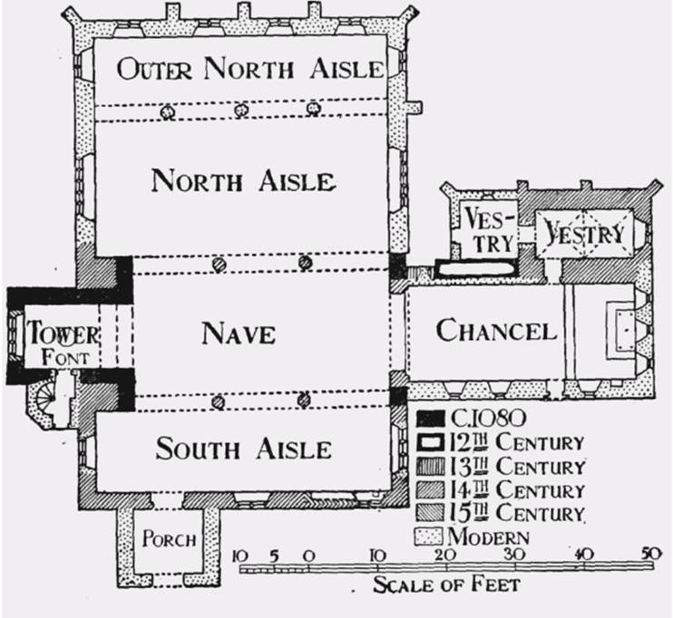
the County of York North Riding: Volume 1 The wapentake of Gilling West, 1914: The church of St Agatha has
developed from an early aisleless nave about 37 ft. by 18 ft. 6 in., with a
chancel probably 16 ft. wide and a west tower oblong in plan, measuring 12 ft.
by 9 ft. within the walls, its east wall being built beyond and not over the
west wall of the nave. Of this building the tower and parts of the nave walls
still stand and date, perhaps, from the end of the 11th century. The present
chancel has been so much refaced and renewed that its history is doubtful, but
a blocked 12th-century arch at the west end of its north wall proves the former
existence of an aisle or chapel here. In the 14th century a vaulted vestry was
added to it at the north-east and about the same time a good deal was being
done to the nave. The present chancel arch, south aisle and arcade were then
built and a few years later an aisle was built on the north side; in each case
the aisles were continued westward beyond the old west wall of the nave and the
space between the old and new west walls filled in, forming great blocks of
masonry on each side of the tower arch. If any older aisles existed there is
now nothing to prove it. In the 15th or 16th century the tower was heightened
and the old belfry windows blocked up, and windows were inserted in different
parts of the church. In 1845 a second north aisle was added, and the church now
consists of a chancel 33 ft. by 14 ft., a north-east vestry 14 ft. by 7 ft.
with a modern extension westward, a nave 37 ft. by 20 ft., a west tower 14 ft.
by 10 ft., a south aisle 43 ft. by 12 ft. with a porch which has been rebuilt,
and two north aisles 43 ft. by 20 ft. and 43 ft. by 9 ft. 6 in. respectively.
The registers begin about 1568.
Fourteenth
century
The Victoria County History
– Yorkshire, A History of the County of York North Riding: Volume 1 The
wapentake of Gilling West, 1914: Gilling
parish in the 14th century included the present parishes of Forcett, Hutton
Magna, South Cowton and Eryholme, besides the chapelries of Barforth and
Mortham.
1475
The Victoria County History – Yorkshire, A History of
the County of York North Riding: Volume 1 The wapentake of Gilling West, 1914: It was granted in 1475 to Richard
Duke of Gloucester, afterwards Richard III, and in 1495 to John Norton of Norton
Conyers, representative of the lords of the adjoining vill of Hartforth, and
his heirs.
1569
The Victoria County History – Yorkshire, A History of
the County of York North Riding: Volume 1 The wapentake of Gilling West, 1914: The Nortons held Hartforth and
Gilling Manors until Richard Norton, one of the ringleaders of the rising in
the north, lost his lands by attainder in 1569.
1571
Sir William Fairfax’s household
books for 1571 to 1582 indicate the significant administrative task to manage
an Elizabethan household. Sir
William Fairfax (1531 to 1 November 1597), of Gilling Castle and Walton,
Yorkshire, was an English politician. He was the eldest son of Sir Nicholas
Fairfax of Gilling, who he succeeded in 1571.
1572
The Victoria County History – Yorkshire, A History of the
County of York North Riding: Volume 1 The wapentake of Gilling West, 1914: The site of the manor was in 1572
leased to William Stockdale for twenty-one years, the manorial rights being
reserved; and the manor was finally granted to Robert Bowes, a younger son of
Richard Bowes of South Cowton, who was treasurer of Berwick and ambassador to
Scotland for nearly twenty-one years, and died in 1597.
1577
Court
records have identified a previously unnoticed survey of the Manor of Gilling,
near Richmond in North Yorkshire, as the work of Christopher Saxton (c 1540 to
c 1610). This new finding adds to the corpus of known maps and surveys made by
Saxton, a pre eminent figure in the new profession of a state surveying. (A Newly Identified Yorkshire Survey by Christopher Saxton, Time Gates, Yorkshire Archaeological Journal, 2025, Volume 97,
No 1, page 103).
1607
Humphrey Wharton (c 1563 to 1636), bought
Gilling manor from Ralph Bowes of Barnes, near Sunderland in County Durham in
November 1607, and built Gillingwood Hall, a fine Jacobean mansion later
inherited by his grandson. (A Newly Identified Yorkshire
Survey by Christopher Saxton, Time Gates, Yorkshire
Archaeological Journal, 2025, Volume 97, No 1, page 105).
1609
The Victoria County History – Yorkshire, A History of
the County of York North Riding: Volume 1 The wapentake of Gilling West, 1914: His son Ralph in 1609 sold it
to Humphrey Wharton, from whom it has descended to the present owner, Mr.
William Henry Anthony Wharton of Skelton Castle.
1750
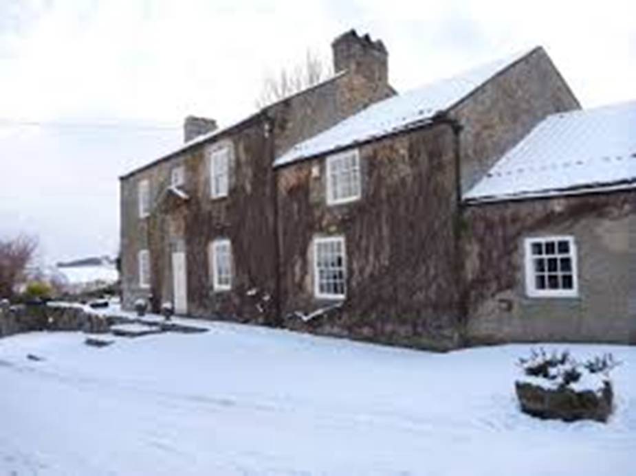
Gillingwood Hall is a late
eighteenth to early nineteenth century farmhouse with a reused early eighteenth
century doorcase. It was owned by the Wharton family. The name of the farm
comes from the mansion of the Wharton family (Old Gillingwood Hall), which
burned down in 1750, and part of the site of which is occupied by the
farmhouse.
1914
The Victoria County History
– Yorkshire, A History of the County of York North Riding: Volume 1 The
wapentake of Gilling West, 1914: The Wapentake of Gilling West
includes the parishes of Arkengarthdale; Barningham; Bowes; Brignall; Easby;
Forcett; Gilling; Hutton Magna or Hutton Longvilliers; Kirkby Ravensworth;
Marrick; Marske; Melsonby; Rokeby with Egglestone Abbey; Romaldkirk; Stanwick
St. John; Startforth; Wycliffe.
The area of the present parish is
2,072 acres of land, more than half of which is laid down to permanent grass,
and 6 acres of land covered by water. In 1810 300 acres of land were enclosed
in Gilling. The subsoil is Yoredale Rocks with alluvium near Dalton and Gilling
Becks. Eryholme is on Keuper Marl.
The village of Gilling lies at the
bottom of the valley between Gatherley Moor and the moors and hills to the
west. It extends along the Melsonby and Richmond road, which is here crossed by
Gilling Beck. The village street is still partly cobbled. At the north end of
the village the road turns up the valley and leads to Hartforth. About 1¼ miles
distant is Hartforth Hall, a modern house built in the classical style, with
the remains of a chapel in the grounds. …
At the north end of the village, about a mile up a by-road running south-east,
is Sedbury Hall, the seat of the lords of Sedbury Manor. Behind it the land
sloping up towards the north forms a large and well-wooded park….
Bibliography
A Newly Identified Yorkshire Survey by
Christopher Saxton, Time Gates, Yorkshire Archaeological
Journal, 2025, Volume 97, No 1, pages 103 to 110.